Weather Outbreak Unleashes 75 to 80 MPH Winds and Embedded Tornadoes Across Iowa Sunday Night With Central Iowa Including Des Moines and Fort Dodge Facing Imminent Danger
DES MOINES, IA — A full scale severe weather outbreak is underway across Iowa at 9:11 PM Sunday as an extended squall line with bowing features races east and northeast through the state, generating 75 to 80 miles per hour wind gusts and several embedded tornadoes along its path. Central and eastern Iowa face the most urgent and immediate danger over the coming hours as the rapidly moving line pushes toward Des Moines and all communities in its path.
Extended Bowing Squall Line Producing 75 to 80 MPH Winds and Embedded Tornadoes
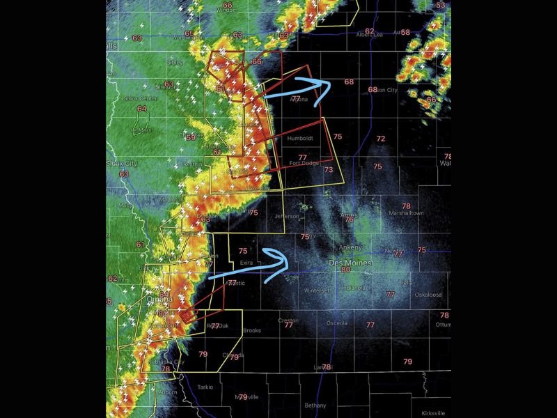
The squall line currently impacting Iowa displays prominent bowing features associated with the most destructive straight line wind events produced by organized storm lines. Wind gusts of 75 to 80 miles per hour are being generated along the leading edge of the bow, with the most intense portions tracking through Spencer, Storm Lake, Sac City, Humboldt, and Fort Dodge as the system races eastward.
Radar imagery at 9:11 PM shows intense red and orange reflectivity returns concentrated along the squall line’s leading edge, with multiple active tornado warning polygons covering a broad zone across northwest and north central Iowa as the outbreak continues its dangerous eastward progression.
Tornadoes Forming Quickly Along the Line Leaving Little Time to React
Tornadoes embedded within this squall line are forming rapidly as the line races east and northeast, leaving residents with very limited time between warning issuance and storm arrival. The rapid forward speed of the squall line significantly compresses the available response window, making immediate shelter action upon warning receipt absolutely critical for all communities from Spencer and Estherville southward through Fort Dodge toward the Des Moines metro corridor.
Central Iowa Including Des Moines Faces Urgent Threat Over the Coming Hours
Des Moines, Ankeny, Ames, Marshalltown, and all surrounding central Iowa communities must be fully prepared and sheltered well before the line arrives. The combination of 75 to 80 mph winds and embedded tornado potential makes this one of the most dangerous storm lines to impact the region this season, with residents across central and eastern Iowa directed to take shelter immediately in the lowest interior room of a sturdy structure until all warnings are officially lifted.
For continuing coverage of severe weather outbreaks and tornado emergencies across the United States, visit SaludaStandard-Sentinel.com.