Decaying Storm Line With Strong Gusty Winds Crosses Lake Michigan Toward Western Lower Michigan at 3:36 AM With Shoreline Arrival Expected Within the Hour
MUSKEGON, MI — A decaying line of storms is being tracked over Lake Michigan at 3:36 AM Eastern Time, moving east and northeast toward western lower Michigan. Strong gusty winds remain possible as the storm line makes its initial approach to the shoreline, though severe weather is not anticipated with this system as it continues to weaken over the open waters of Lake Michigan ahead of its landfall along the western Michigan coast.
Decaying Storm Line Tracks East Northeast Over Lake Michigan Toward the Shoreline
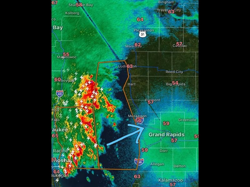
Radar imagery at 3:36 AM shows the storm line positioned over Lake Michigan with intense red and yellow reflectivity returns still present within the core of the system despite its overall decaying trend. Numerous lightning strikes are visible across the storm complex as it pushes east and northeast over the open lake waters, with the leading edge of the system approaching the western Michigan coastline in the vicinity of Muskegon and Ludington.
The storm line’s arrival along the western lower Michigan shoreline is expected within the next hour from the time of observation, meaning communities along the coast from Muskegon northward toward Ludington and Manistee should be prepared for the system’s onshore movement during the early morning hours.
Strong Gusty Winds Possible as Line Makes Initial Landfall Along Western Michigan Coast
While the overall severe weather threat is considered low with this decaying system, strong gusty winds remain a credible hazard as the storm line first moves onshore along the western Michigan coast. The initial landfall of a storm line crossing Lake Michigan can produce brief but notable wind gusts, particularly along the immediate shoreline communities where the transition from open water to land occurs.
An active warning polygon outlined in orange on radar maps covers a broad zone along the western Michigan coastline stretching from the Muskegon area northward through Ludington, reflecting the continued monitoring of this system as it approaches land despite its weakening characteristics over the lake.
Severe Weather Not Expected but Residents Should Remain Weather Aware
Forecasters do not anticipate severe weather to occur with this particular storm line as it moves onshore and continues its eastward progression into western lower Michigan. The decaying nature of the system over Lake Michigan suggests the most intense storm energy will remain offshore, with the onshore portion of the event primarily characterized by gusty winds, lightning, and moderate rainfall rather than severe thunderstorm conditions.
Residents across Muskegon, Ludington, Manistee, Hart, and surrounding western Michigan communities are nonetheless encouraged to remain weather aware through the early morning hours as the storm line completes its crossing of Lake Michigan and moves inland across the region.
For continuing coverage of overnight storm tracking and severe weather updates across the United States, visit SaludaStandard-Sentinel.com.