Tornado Outbreak Possible Across Oklahoma Kansas Nebraska and Iowa Monday Afternoon Through Overnight With SPC Warning of Strong to Intense EF3 Long Track Tornadoes and Giant Hail
KANSAS CITY, MO — The Storm Prediction Center has issued a rare and alarming extended outlook indicating a high probability of a widespread severe weather event and potential tornado outbreak across the Central Plains and Upper Midwest on Monday afternoon and evening. The use of outbreak-level language in an extended outlook by the SPC is considered highly unusual and underscores the seriousness of the developing atmospheric setup across Oklahoma, Kansas, Nebraska, Iowa, Missouri, and Wisconsin.
SPC Highlights Volatile Airmass Capable of Supercell Development Across the Plains
Forecast guidance from the Storm Prediction Center indicates numerous thunderstorms are expected to develop along and ahead of a cold front and further south along the dryline Monday afternoon and evening from Nebraska into central Kansas. The volatile airmass ahead of these features features moderate to strong instability combined with strengthening deep layer shear, conditions that strongly favor initial storm development taking on supercellular characteristics.
These initial supercells will pose a risk of all hazards simultaneously, including large to very large hail, damaging winds, and tornadoes across the entire affected corridor from the Central Plains into the Upper Midwest.
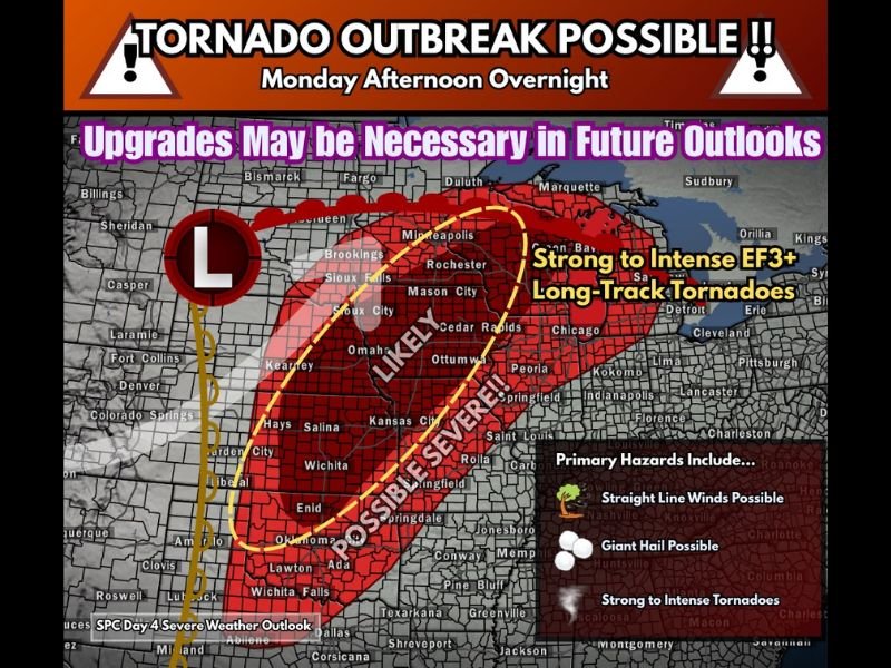
Strong to Intense EF3 Long Track Tornadoes Among the Primary Threats
As the southwesterly low level jet increases into the evening hours, large clockwise enhancement of low level hodographs across portions of central Kansas into northern Oklahoma is expected to drive an increasing risk for strong to intense tornadoes. The SPC outlook specifically highlights the potential for EF3 or stronger long track tornadoes capable of remaining on the ground for extended distances across the threat zone.
Outlook maps show a likely severe corridor centered across Omaha, Kansas City, and Cedar Rapids, with a possible severe zone extending from Enid and Oklahoma City northward through Wichita, Salina, and into the Upper Midwest. Future outlook upgrades are considered likely as the event draws closer and forecast confidence increases.
Giant Hail and Straight Line Winds Round Out a Dangerous Hazard Profile
Beyond the tornado threat, the Monday severe weather setup carries additional primary hazards including giant hail and straight line winds across the affected states. The combination of these three hazard types simultaneously across such a broad geographic area reflects the exceptional nature of the atmospheric setup driving this potential outbreak event.
The possible severe zone on current SPC maps extends from Texas and Oklahoma northward through Kansas, Nebraska, Iowa, Missouri, and into Wisconsin, covering a densely populated multi-state corridor that includes several major metropolitan areas.
Residents Across Six States Urged to Have Severe Weather Plans in Place
Residents across Oklahoma, Kansas, Nebraska, Iowa, Missouri, and Wisconsin are strongly urged to establish and review their severe weather action plans well before Monday arrives. Having multiple methods to receive tornado warnings, knowing the location of the nearest sturdy shelter, and avoiding storm fatigue throughout what could be a prolonged outbreak event are all critical steps for communities across the entire threat zone.
Given the SPC’s rare use of outbreak level language this far in advance, meteorologists stress that further upgrades to the outlook are anticipated and that the situation should be monitored closely with each forecast update through the weekend.
For continuing coverage of severe weather outbreaks and critical storm forecasts across the United States, visit SaludaStandard-Sentinel.com.