Five Day Severe Weather Stretch With Tornadoes Wind and Hail Targets Northern Illinois and Southern Wisconsin From Friday Through Tuesday With Monday Carrying All Mode Severe Threat
ROCKFORD, IL — A five-day severe weather stretch is developing across Northern Illinois and Southern Wisconsin from Friday through Tuesday, with multiple rounds of potentially severe thunderstorms carrying wind, hail, and isolated tornado threats across the region as a warmer and gradually more humid pattern returns, with Monday standing out as the most significant and dangerous day of the entire active period.
Friday and Saturday Open the Active Stretch
Friday brings the first severe weather opportunity with a Level 1 Marginal Risk during the late evening and overnight hours, with wind and some hail as the primary threats across the Northern Illinois and Southern Wisconsin corridor. Saturday follows with another Marginal Risk during the late afternoon and evening, again featuring wind and hail as the main hazards before a more organized and dangerous setup develops heading into Sunday.
Both Friday and Saturday demand awareness even at the lower threat level, as stronger storms are possible ahead of the more significant weekend and early week events.
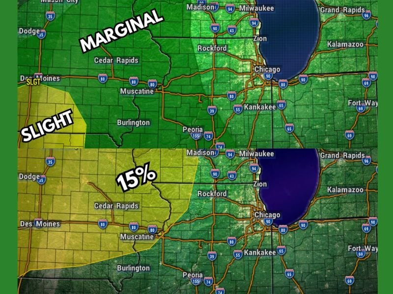
Sunday Brings Isolated Tornado Risk West and North of Rockford
Sunday afternoon and evening carries a Level 1 Marginal Risk for most of the region but escalates to a Level 2 Slight Risk west and north of Rockford, where isolated tornadoes join wind and hail as primary threats. Severe weather risk mapping shows a 15 percent tornado probability for the Sunday and Sunday night period across the western Illinois and southern Wisconsin corridor, a meaningful probability that demands serious attention from residents across the affected zone.
Wind, hail, and isolated tornadoes all remain in play across the broader Northern Illinois and Southern Wisconsin area through the Sunday evening timeframe.
Monday the Most Dangerous Day With All Modes Possible
Monday emerges as the most significant severe weather day of the entire five-day stretch, carrying a Level 2 Slight Risk with storms possible at any time and best chances during the afternoon and evening hours. All severe weather modes are explicitly identified as being in play on Monday, meaning tornadoes, damaging winds, and large hail are all simultaneously possible across the region.
Tuesday closes the active period with a Marginal Risk for most areas and a Slight Risk southwest of Rockford, where isolated tornadoes and areawide winds remain concerns during the mainly early timing window.
For continuing coverage of severe weather events and critical storm analysis across the United States, visit SaludaStandard-Sentinel.com.