Most Tornadoes Never Fully Condense to the Ground Making Them Harder to Spot Across the United States as Focused Rotation and Ground Debris Remain the Key Warning Signs
UNITED STATES — One of the most dangerous and widely misunderstood aspects of tornado identification is that most tornadoes never develop the dramatic elephant trunk or cone shape that many people associate with these storms, with the condensation funnel frequently failing to extend fully to the ground even while the tornado’s circulation is actively making contact and causing destruction at the surface.
Most Tornadoes Never Fully Condense Visibly
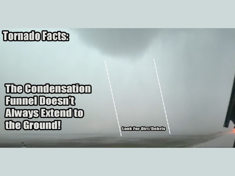
While the classic image of a tornado features a clearly defined funnel stretching dramatically from cloud base to ground, this fully condensed appearance represents a minority of actual tornado events. The visible funnel cloud is formed by condensing water vapor, and the degree to which it extends downward depends entirely on atmospheric moisture levels and temperature at various altitudes rather than the actual strength or ground contact of the tornado itself.
Many tornadoes, particularly weaker ones, appear only as slight bowl-shaped or nub-like lowerings at the cloud base while their circulation simultaneously reaches and damages the ground below.
Two Dangerous Misconceptions Among the Public
The incomplete condensation of tornado funnels creates two opposing but equally dangerous public misconceptions. The first is failing to recognize an actual tornado because it lacks the expected full funnel appearance, leading residents to dismiss a genuine and life-threatening tornado as simply a suspicious cloud feature.
The second misconception is the opposite problem, where people mistake every cloud lowering or scud feature for a tornado, creating unnecessary panic and reducing overall credibility when genuine warnings are issued across the affected community.
Focused Rotation and Ground Debris Are the Real Indicators
The most reliable method for identifying a tornado when a clear condensation funnel is absent is observing focused and rapid rotation at the cloud base, which even weak tornadoes typically display. Dust or debris swirling at or near the ground beneath a suspicious cloud lowering represents another critical visual clue that tornado contact is occurring at the surface regardless of what the visible funnel appears to show above.
However, forecasters caution that ground debris can sometimes be produced by outflow winds rather than actual tornado contact, making visual identification genuinely challenging even for experienced observers during active severe weather events.
For continuing coverage of severe weather events and critical storm analysis across the United States, visit SaludaStandard-Sentinel.com.