Warmup Bringing 70s and 80s to the Mid-Atlantic and Northeast by End of Next Week as Above Average Temperatures Build Across the Region From Cincinnati to Philadelphia During May 15 to 19
PHILADELPHIA, PA — A welcome and significant warmup is on the way for the Mid-Atlantic and Northeast regions, with temperatures expected to climb into the 70s and 80s by the end of next week as an above-average temperature pattern builds across a broad corridor stretching from Cincinnati and Cleveland through Washington, Philadelphia, and Norfolk during the May 15 to 19 outlook period.
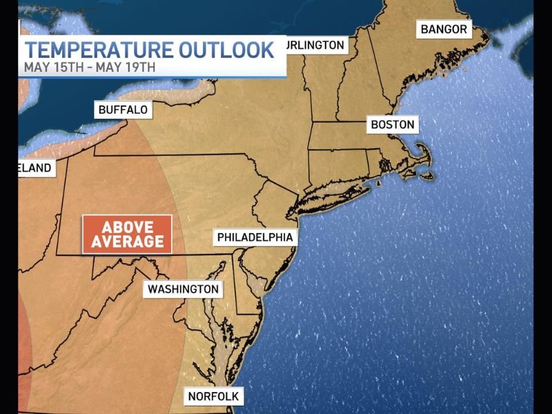
Above Average Temperatures Building Across the Region
The First Alert Weather Temperature Outlook valid from May 15 through May 19 clearly depicts an expanding above-average temperature signal advancing across the Mid-Atlantic and into portions of the Northeast, shown in warm orange and red tones across the western and central portions of the region.
The above-average signal is most pronounced across the interior Mid-Atlantic and Ohio Valley corridor, encompassing communities from Cincinnati and Cleveland eastward through Washington and Philadelphia as the warming pattern takes hold through the second and third weeks of May.
This temperature departure from seasonal norms represents a meaningful and noticeable shift for residents who have endured a persistently cool and active spring pattern across much of the eastern United States in recent weeks.
70s and 80s Expected by End of Next Week
The most anticipated aspect of the upcoming temperature outlook is the arrival of 70s and 80s degree readings across the region by the end of next week, delivering the kind of warm and comfortable conditions that signal the true arrival of late spring warmth across the Mid-Atlantic and surrounding areas. Communities including Washington, Philadelphia, Norfolk, and Cincinnati are among those expected to see the most pronounced warm temperature readings as the pattern peaks during the May 15 to 19 window.
The combination of above-average temperatures and the seasonal increase in sunshine duration will make conditions feel noticeably more summerlike across the affected corridor during this period.
Coastal New England Remains on the Cooler Side
While the warming trend brings relief to much of the Mid-Atlantic and interior Northeast, the temperature outlook shows a notably cooler signal persisting across coastal New England, with communities including Boston, Burlington, and Bangor remaining on the cooler side of the temperature departure pattern during the May 15 to 19 period. The marine influence along the New England coastline typically moderates temperature swings, keeping coastal areas cooler than interior locations even during periods of significant inland warmth.
Residents across coastal Massachusetts, Maine, and Vermont should temper expectations for the warmup compared to their counterparts further south and west across the region. For continuing coverage of severe weather events and critical storm analysis across the United States, visit SaludaStandard-Sentinel.com.