NWS Jackson Confirms Long-Track EF-3 Tornado Carved 70-Plus Mile Path From Meadville to Monticello Mississippi on May 6 After Reinvigorating Following a Mid-Track Failed Cycle
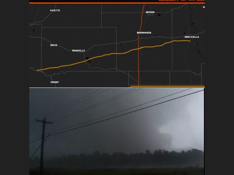
BROOKHAVEN, MS — The National Weather Service office in Jackson has officially confirmed a long-track EF-3 tornado that carved a continuous ground path exceeding 70 miles across south-central Mississippi on Wednesday, May 6, 2026, tracking from the Crosby and Meadville area eastward all the way through Brookhaven and continuing to Monticello in what represents one of the longest-tracked and most destructive single tornado events to impact the region in recent history.
70-Plus Mile Confirmed Track Across South-Central Mississippi
Track mapping released following the NWS Jackson confirmation shows the tornado’s full path stretching in a nearly straight line from the southwestern corner of the affected zone near Crosby and Meadville, advancing northeast through Franklin and Lincoln counties, passing directly through Brookhaven, and continuing eastward to Monticello. The confirmed track length of over 70 miles places this tornado firmly in the long-track category, a designation reserved for tornadoes that maintain continuous or near-continuous ground contact across an exceptionally extended distance.
Long-track tornadoes of this nature pose an amplified public safety threat due to the sheer number of communities, roadways, and rural areas they expose to violent winds across their extended path.
Tornado Reinvigorated After Mid-Track Failed Cycle
One of the most meteorologically significant aspects of this tornado event is the confirmed behavior change that occurred during the storm’s track. Radar analysis indicated that a failed mesocyclone cycle appeared to occur at approximately the midpoint of the tornado’s path, a process that often signals the weakening and dissipation of a tornado. However, rather than dying out, this storm reinvigorated and intensified through the second half of its track, extending its destructive reach significantly beyond what the mid-track radar signature initially suggested.
This reinvigoration pattern contributed directly to the tornado maintaining EF-3 intensity across an unusually long distance, maximizing the damage footprint across multiple Mississippi counties simultaneously.
Massive Wedge Observed From Birth at 7:40 PM
The tornado was observed as a massive wedge from the moment of its formation, with ground-level documentation capturing the storm at 7:40 PM on May 6th as it developed into a large and visually identifiable wedge structure. The confirmed wedge classification is consistent with the EF-3 rating and 70-plus mile track, as wedge tornadoes typically maintain stronger and more sustained ground contact than narrower tornado types due to their broader circulation and deeper mesocyclone structure driving them.
For continuing coverage of severe weather events and critical storm analysis across the United States, visit SaludaStandard-Sentinel.com.