Heavy Rain and Flash Flood Threat Targets Gulf Coast From New Orleans to Pensacola on Friday May 8 as High-Resolution Models Trend Heavier With Extreme Storm Returns Over Biloxi and Waveland
NEW ORLEANS, LA — High-resolution forecast models are trending progressively heavier with rainfall projections for Friday, May 8, 2026, raising flash flood concerns across the Gulf Coast corridor stretching from Baton Rouge and New Orleans eastward through Biloxi, Pascagoula, Mobile, and into Pensacola, as storm training over already rain-saturated ground threatens to compound flooding conditions across the region by early afternoon.
Models Trending Heavier Ahead of Friday Storm System
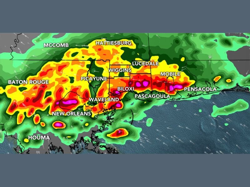
As of the 9:17 PM update on May 7, 2026, high-resolution forecast models have been consistently trending toward heavier rainfall totals for the Friday timeframe, signaling that the storm system pushing through the Gulf Coast will deliver more significant precipitation than earlier model runs had suggested. The WLOX First Alert Futurecast valid for 2:00 PM Friday shows an expansive and intense band of precipitation draped across the entire Gulf Coast from southeastern Louisiana through coastal Mississippi and into the western Florida Panhandle.
The most extreme radar return signatures, depicted in magenta and deep pink on the futurecast imagery, are concentrated directly over New Orleans, Waveland, Biloxi, and Pascagoula, indicating the heaviest rainfall cores are forecast to impact these communities during the early to mid-afternoon hours on Friday.
Flash Flooding the Primary Concern
While the overall severe weather risk is assessed as low, forecasters are explicit that the threat is not zero, and flash flooding has emerged as the dominant concern heading into Friday. The critical flash flood scenario involves storm training, a situation where successive rounds of heavy thunderstorms repeatedly pass over the same geographic areas rather than moving through quickly, resulting in rainfall totals that accumulate far beyond what a single storm would deposit.
Given that portions of the Gulf Coast region have already received substantial rainfall in recent days, the ground across many areas is already at or near saturation capacity, meaning even moderate additional rainfall could trigger rapid water rises across low-lying neighborhoods, drainage systems, and roadways throughout the warned corridor.
Extreme Returns Forecast Over Coastal Mississippi and Louisiana
The futurecast imagery for 2:00 PM Friday shows the most intense precipitation returns centered over a coastal zone encompassing Waveland, Biloxi, Pascagoula, and the greater New Orleans metropolitan area extending toward Houma. The magenta-coded returns visible in this zone represent the highest rainfall rate category on the forecast scale, underscoring the potential for extremely heavy and potentially dangerous rainfall rates during the peak of the Friday afternoon storm activity across coastal Louisiana and Mississippi.
Communities including McComb, Hattiesburg, Picayune, Wiggins, and Lucedale also fall within the broader heavy rain footprint shown in the forecast imagery.
Gulf Coast Residents Urged to Monitor Friday Conditions Closely
Residents across the Gulf Coast from Baton Rouge and New Orleans through coastal Mississippi and into Mobile and Pensacola are strongly advised to monitor Friday weather conditions closely as the storm system develops and high-resolution model data continues to be refined through the overnight hours. Avoiding flood-prone roadways, staying informed through official weather alerts, and having contingency plans in place ahead of the Friday afternoon storm window will be critical for public safety across the region.
For continuing coverage of severe weather events and critical storm analysis across the United States, visit SaludaStandard-Sentinel.com.