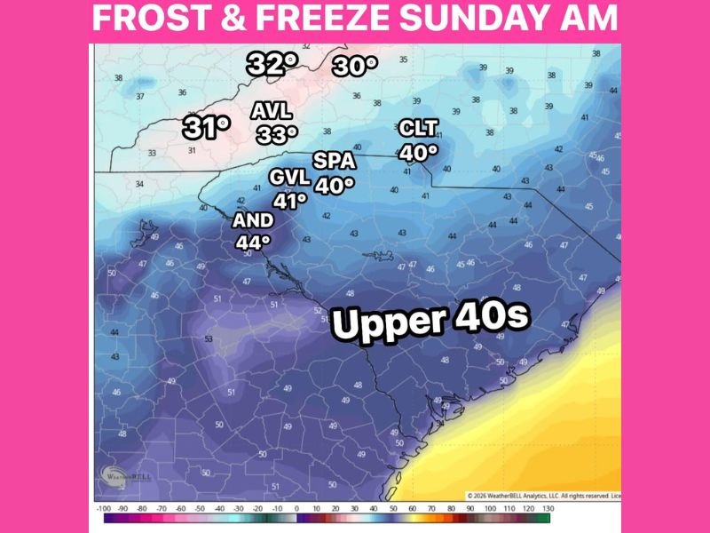
Frost and Freeze Threat Sunday Morning Drops Mountain Temperatures Near or Below Freezing Across Western North Carolina and Upstate South Carolina With Asheville at 33 and Charlotte at 40 Degrees
ASHEVILLE, NC — A cold north wind pouring in behind Saturday’s rain was set to deliver a frost and freeze threat across the Carolinas on Sunday morning, with mountain temperatures forecast to drop near or below freezing and upstate communities settling into the mid to upper 30s in a late season cold snap raising significant concern for crops and apple orchards across the region.
Temperature forecast maps showed readings as low as 30 degrees across the highest terrain of western North Carolina, with Asheville forecast at 33 degrees, Spartanburg at 40 degrees, Greenville at 41 degrees, Anderson at 44 degrees, and Charlotte at 40 degrees as the cold north wind drove temperatures to dangerously low levels for late spring agricultural interests.
Mountain Communities Face Near or Below Freezing Temperatures
The most critical cold air impact was forecast across the mountain communities of western North Carolina where temperatures were expected to drop near or below the 32 degree freezing mark Sunday morning. Readings of 30 to 32 degrees were depicted across the highest terrain zones, placing mountain crops, fruit trees, and sensitive vegetation at serious risk of freeze damage during the Sunday morning cold snap.
Apple trees across the mountain agricultural corridors of western North Carolina were identified as particularly vulnerable to the freezing temperatures, with the late season timing of the cold event making the frost and freeze threat especially damaging for orchards already progressing through critical spring growth stages.
Upstate South Carolina Settles Into Mid to Upper 30s
Across upstate South Carolina, temperatures were forecast to drop into the mid to upper 30s during the Sunday morning hours, placing Greenville at 41 degrees and Spartanburg at 40 degrees within the coldest readings expected for the upstate corridor. While these temperatures fell just above the official freezing mark, the combination of cold air and residual moisture from Saturday’s rain created favorable conditions for frost formation across low-lying areas and open agricultural fields throughout the upstate region.
Anderson at 44 degrees represented the warmest of the highlighted upstate South Carolina readings, while coastal South Carolina and the broader Midlands region settled into the upper 40s through the Sunday morning hours as the cold air mass lost some intensity with distance from the mountains.
Crop Damage Concern Elevated Across the Region
The frost and freeze threat arriving Sunday morning carried elevated concern for agricultural interests across both western North Carolina and upstate South Carolina. Temperatures right on the edge of freezing combined with calm wind conditions overnight created the optimal setup for surface frost formation even in locations where air temperatures remained technically above 32 degrees, making the agricultural damage potential broader than the official freezing line alone suggested.
Residents and agricultural operators across the mountain and upstate corridor were advised to monitor updated temperature forecasts closely through Saturday night and take appropriate protective measures for sensitive crops and vegetation ahead of the Sunday morning frost and freeze event.
For continuing coverage of weather events and critical storm analysis across the United States, visit SaludaStandard-Sentinel.com.