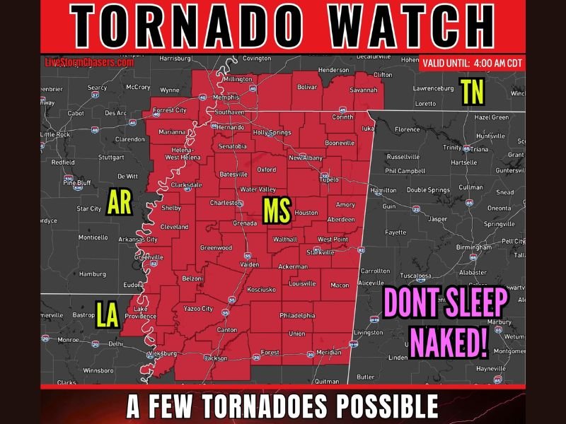
Tornado Watch Issued Across Arkansas Louisiana Mississippi and Tennessee With Tornadoes Possible Golf Ball Sized Hail and 70 MPH Winds Threatening Four States Until 4 AM CDT
MEMPHIS, TN — A Tornado Watch was issued across parts of Arkansas, Louisiana, Mississippi, and Tennessee until 4:00 AM CDT as numerous storms were already ongoing across the region, bringing a dangerous overnight combination of possible tornadoes, large hail up to 1.5 inches in diameter, and damaging winds reaching up to 70 miles per hour across a wide four-state corridor.
The watch zone covered a densely populated stretch of communities including Memphis, Southaven, Hernando, Holly Springs, Corinth, Tupelo, Oxford, Batesville, Clarksdale, Grenada, Starkville, Jackson, Meridian, Vicksburg, and surrounding areas across the mid-South region.
Mix of Storm Modes Creates Layered Tornado Threat
The overnight severe weather setup featured a dangerous mix of storm modes across the four-state watch area. Northern portions of the region were expected to mainly see a line of storms capable of producing damaging winds and quick spin-up tornadoes embedded within the squall structure, while southern areas faced the potential for more discrete supercell development carrying a higher and more focused tornado risk.
Strong low-level wind shear across the region was identified as a key ingredient supporting tornado potential within both storm modes through the overnight hours, making the watch valid and significant across the full geographic extent of the four affected states.
Golf Ball Sized Hail and 70 MPH Winds Accompany the Threat
Beyond the tornado risk, large hail ranging from ping pong to golf ball size measuring up to 1.5 inches in diameter posed a significant property damage threat across the watch zone. Damaging winds reaching up to 70 miles per hour remained possible with the stronger storm cells moving through the region, capable of downing trees, snapping power lines, and causing widespread structural damage across communities within the active watch boundary.
The combination of all three hazards simultaneously across such a large geographic area elevated the overnight threat level considerably for residents across Arkansas, Louisiana, Mississippi, and Tennessee.
Four State Watch Zone Demands Overnight Vigilance
With the tornado watch valid until 4:00 AM CDT and storms already ongoing across the region at the time of issuance, residents across all four states were urged to maintain active weather awareness through the overnight hours. Having multiple methods of receiving warnings, keeping devices fully charged, and having an established shelter plan ready for immediate execution represented the critical preparation steps for all communities within the four-state watch corridor.
For continuing coverage of severe weather events and critical storm analysis across the United States, visit SaludaStandard-Sentinel.com.