Nasty Supercells With Golf to Tennis Ball Sized Hail Targeting Dallas Frisco McKinney Plano and Surrounding DFW Communities in Widespread and Intense Storm Setup
DALLAS, TX — Models painted a dangerous and widespread supercell threat across the Dallas-Fort Worth metroplex for late Tuesday afternoon through midnight, with storm intensity forecast to exceed the previous day’s already damaging setup that produced golf to tennis ball sized hail across Rowlett, Rockwall, Fate, Quinlin, and Commerce.
Tuesday’s storm setup was described as more widespread and carrying a little more intensity compared to the prior day’s event, with the cold front expected to arrive after midnight to finally clear the region following what was shaping up to be a long and active severe weather day across the DFW corridor.
Supercell Models Paint a Dangerous Picture for DFW
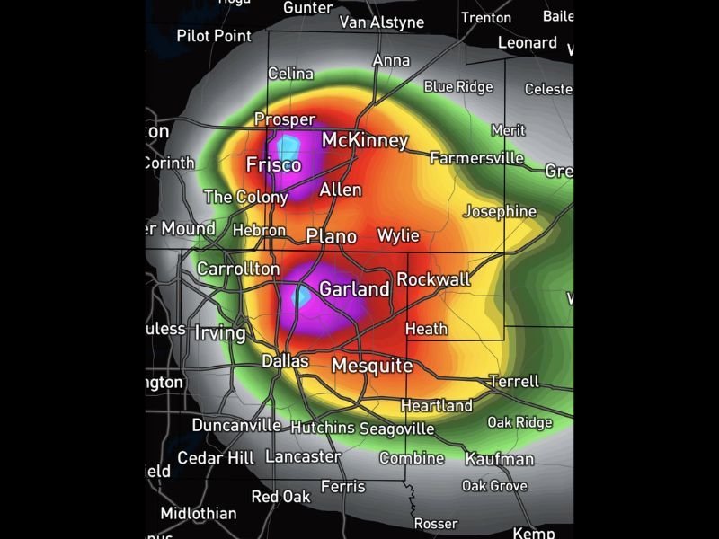
Model data showed intense supercell development targeting the heart of the Dallas-Fort Worth metroplex during the late Tuesday afternoon hours. Simulated radar imagery displayed deep purple and magenta reflectivity cores concentrated directly over Frisco, McKinney, Plano, Garland, Allen, The Colony, Carrollton, and Dallas, indicating the potential for extremely intense storm cells capable of producing large and destructive hail across one of the most densely populated urban corridors in Texas.
The broad and intense reflectivity signature shown on model output covered a wide geographic area stretching from Pilot Point and Celina in the north through Prosper, McKinney, and Farmersville to the northeast, while extending south through Garland, Mesquite, Rockwall, and into Cedar Hill, Lancaster, and Midlothian.
Golf to Tennis Ball Hail Already Caused Damage the Day Before
The severity of Tuesday’s threat was placed in sharp context by the hail damage already reported across multiple DFW communities from the previous day’s storm event. Golf to tennis ball sized hail struck Rowlett, Rockwall, Fate, Quinlin, and Commerce, causing significant property damage across those areas east of the dryline where storms had been perfectly forecasted.
With Tuesday’s setup described as more widespread and intense, the potential for hail of similar or greater size striking a broader swath of the metroplex represented a serious and immediate property threat for communities across the entire DFW region.
Storms Expected to Persist Through Midnight
Unlike a quick-moving storm event, Tuesday’s severe weather setup was forecast to keep active storm activity in place across the DFW area through midnight before the arriving cold front finally pushed the system out of the region. The extended duration of the threat window meant residents could not assume the danger had passed until the frontal clearing was confirmed well into the overnight hours.
Parking vehicles undercover ahead of storm arrival was strongly advised given the documented hail threat, with the intensity and widespread nature of the Tuesday supercell setup creating significant risk for vehicle and property damage across the full metroplex corridor through the midnight cold front passage.
For continuing coverage of severe weather events and critical storm analysis across the United States, visit SaludaStandard-Sentinel.com.