Giant Hail Threat and Potential Tornado Risk Targets All of DFW and Areas East Under Enhanced Risk Severe Weather Outlook for Tuesday April 28 2026
DALLAS-FORT WORTH, TX — A significant and potentially historic severe weather day was taking shape for the Dallas-Fort Worth metroplex and areas east on Tuesday, April 28, 2026, as the Storm Prediction Center issued a Severe Weather Outlook placing Dallas and surrounding communities under an Enhanced risk while an escalating concern for large to giant hail and a developing tornado threat loomed over the entire DFW region through the evening hours.
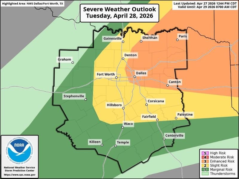
The outlook, last updated April 27, 2026 at 12:44 PM CDT and valid through April 29 at 7:00 AM CDT, highlighted a broad swath of North and Central Texas under varying risk levels, with the Enhanced risk zone covering Dallas, Fort Worth, Denton, Sherman, Canton, Corsicana, and Palestine.
Giant Hail Threat Raises Alarm Across the Entire Metroplex
The hail threat for Tuesday was described as a large to giant level concern for all of DFW and areas to the east. Storm fuel was forecast to be very large, creating an environment where any storm that developed carried the potential to explode rapidly and produce exceptionally damaging hail across the metroplex corridor.
Giant hail, classified as hail exceeding two inches in diameter, causes catastrophic damage to vehicles, rooftops, windows, and any exposed property or individuals caught outdoors. The scale of the threat extended across the full DFW area without exception, placing every community within the metroplex at risk for significant hail impact through the Tuesday evening timeframe.
Tornado Threat Developing Alongside Hail Concerns
Beyond the dominant hail threat, an evolving tornado risk was also identified for the Tuesday severe weather event. Sufficient overlap of atmospheric spin and instability raised the possibility of tornado development accompanying the exploding storm cells, adding a second life-threatening hazard layer to an already dangerous severe weather setup for the metroplex and surrounding east Texas communities.
The tornado threat was expected to be concentrated in the evening hours as storm activity intensified and the atmospheric environment became increasingly favorable for rotating storm development across the Enhanced risk zone.
Risk Levels Vary Across the NWS Dallas Fort Worth Highlighted Area
The Storm Prediction Center outlook map showed a graduated risk structure across the NWS Dallas-Fort Worth highlighted area. The Enhanced risk zone covered Dallas, Fort Worth, Denton, Sherman, Paris, Canton, Corsicana, Fairfield, and Palestine. A Slight risk extended outward through Gainesville, Hillsboro, Waco, and Centerville while a Marginal risk covered the outermost areas including Graham, Stephenville, Killeen, and Temple.
Residents across all risk categories were advised to finalize shelter plans and secure vehicles undercover ahead of Tuesday evening storm development. For continuing coverage of severe weather events and critical storm analysis across the United States, visit SaludaStandard-Sentinel.com.