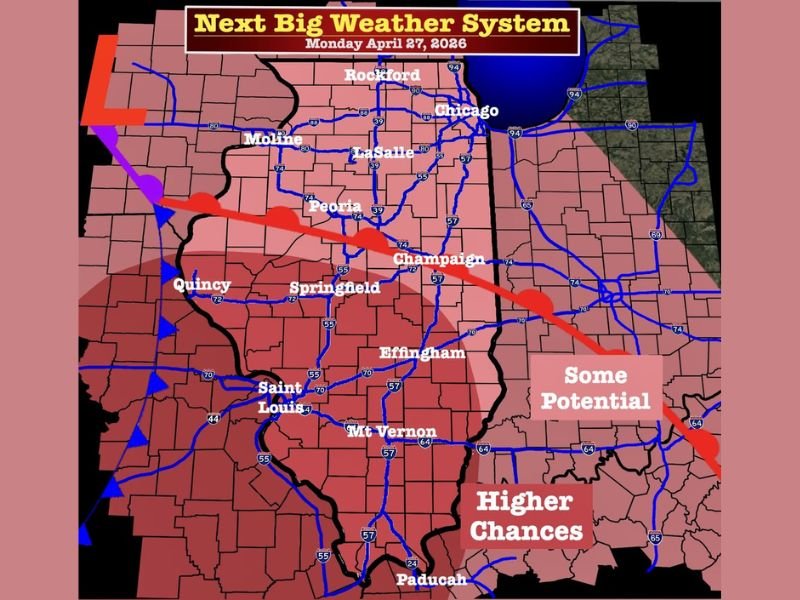
Significant Severe Weather Setup Targets Illinois Monday as Cold Front Brings Tornado, Wind and Hail Risk From Chicago to Springfield and Paducah
ILLINOIS — A potentially significant severe weather setup is being monitored for Monday, April 27, 2026, as a powerful cold front moves east into Illinois and brings a warm, moist and unstable air mass into the region. The latest outlook highlights much of Illinois, including Chicago, Rockford, Peoria, Springfield, Champaign, Effingham and Mount Vernon, with severe storms possible during the afternoon and evening hours.
Powerful Cold Front Raises Severe Storm Concern
The setup shown on the weather map places a strong cold front pushing into Illinois while a warm front remains in the region. That combination could create an unstable atmosphere capable of supporting strong to severe thunderstorms.
The concern is increased by strong wind shear positioned across the storm zone. When shear interacts with warm and humid air, storms can rotate and become more organized.
Tornadoes, Damaging Winds and Hail All Possible
The forecast discussion notes that all modes of severe weather are on the table, including tornadoes. Damaging straight-line winds and large hail could also become threats depending on how storms develop Monday.
The most concerning zone appears to stretch from western and central Illinois into southern Illinois, with higher chances marked across areas closer to Springfield, Mount Vernon, Saint Louis and Paducah.
Afternoon Into Evening Timing Favored
Current timing points toward an afternoon into evening severe weather window. That timing is important because daytime heating can help storms strengthen before moving across populated areas and major travel routes. Cities such as Peoria, LaSalle, Champaign, Springfield and Effingham may need to watch later updates closely as details become clearer.
Forecast Still Needs More Analysis
While the environment appears supportive of significant severe weather, some questions remain about exact storm placement, timing and intensity. The outlook cautions against calling this a major outbreak too early.
Residents should monitor updates through the weekend and prepare for possible watches or warnings if confidence increases. For now, the key message is to stay weather-aware, review shelter plans and avoid panic while waiting for more refined forecast details.
People across Illinois and nearby areas can share how they are preparing for Monday’s storm threat. Stay with SaludaStandard-Sentinel.com for more updates on severe weather risks, timing and local impacts.