2 to 3 Inches Rain Forecast Across North Alabama and Tennessee Over the Next 7 Days Bringing Much Needed Moisture to Huntsville, Decatur, Cullman and Surrounding Areas
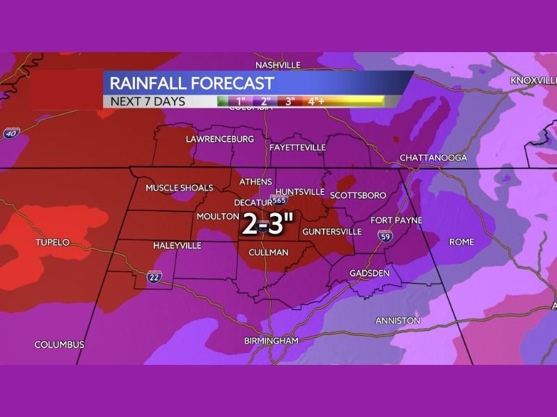
NORTH ALABAMA — Several weather systems moving through the region between now and Tuesday of next week are expected to deliver beneficial rainfall across North Alabama and surrounding portions of Tennessee, with totals of 2 to 3 inches possible across the core of the forecast area. The WAAY 31 StormTracker 7-day rainfall forecast, posted Wednesday April 22, 2026, shows the heaviest accumulation zone centered across a corridor including Huntsville, Decatur, Athens, Cullman, Moulton, and Guntersville.
Forecasters note that aside from the severe weather chances associated with some of these systems, the overall rainfall outlook is a positive development for an area that has seen dry conditions in recent weeks.
Heaviest Rainfall Zone Centered Across North Alabama
The deepest purple and red shading on the 7-day rainfall forecast map is concentrated across the heart of North Alabama, where 2 to 3 inches of total accumulation is projected through next Tuesday. Communities sitting within this primary rainfall zone include Huntsville, Decatur, Athens, Scottsboro, Moulton, Cullman, Guntersville, and Fort Payne.
This corridor represents the bullseye of beneficial rainfall for the entire 7-day period, and the accumulation totals shown here are meaningful enough to provide genuine relief to dry soils and vegetation across the region.
Surrounding Areas Also Picking Up Significant Rainfall
Beyond the core 2 to 3 inch zone, the broader rainfall footprint extends across a wide surrounding area. Muscle Shoals, Haleyville, and Lawrenceburg to the west and north fall within a zone of 2 inches or more of projected rainfall. Fayetteville and the Tennessee communities near Nashville and Columbia are also within the general rainfall area, picking up meaningful accumulation during the 7-day window.
Further south, Gadsden, Anniston, and Birmingham are within the outer rainfall zone, while communities including Tupelo and Columbus to the west may also receive beneficial precipitation during this period. Chattanooga and Rome to the east fall within the lighter accumulation zone on the eastern fringe of the forecast area.
Timing Spread Across Multiple Weather Systems
The projected 2 to 3 inch rainfall total will not arrive all at once but rather in multiple rounds as several weather makers move through the region between now and next Tuesday. This staggered delivery of rainfall across multiple systems means that communities will see a series of rain events rather than one prolonged soaking period.
Forecasters are encouraging residents to view this as a positive overall pattern despite the severe weather concerns associated with some of the individual storm systems expected during the week. The net result of multiple rainfall-producing systems moving through the region should be a meaningful boost to soil moisture across North Alabama and Tennessee.
Are you welcoming the beneficial rainfall forecast across North Alabama and Tennessee this week? Share what conditions look like in your area and stay informed with the latest coverage at SaludaStandard-Sentinel.com.