Explosive Storm Development Possible Thursday Afternoon Across Oklahoma, Northwest Texas and South Central Kansas if Atmospheric Cap Breaks With All Severe Weather Modes at Risk
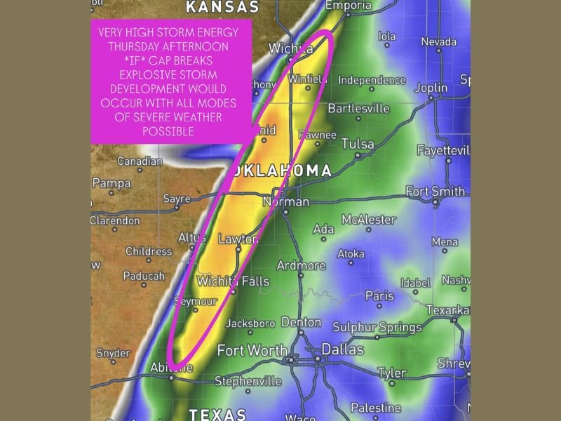
OKLAHOMA, NORTHWEST TEXAS AND SOUTH CENTRAL KANSAS — A potentially explosive and high-end severe weather setup is taking shape for Thursday afternoon across a corridor stretching from northwest Texas through Oklahoma and into south-central Kansas, and forecasters are watching it very closely. Very high to extreme storm energy is expected to develop ahead of the dryline during Thursday afternoon, creating the atmospheric ingredients needed for surface-based storms to explode in development if conditions align correctly.
The critical factor that will determine whether this becomes a major severe weather outbreak or a quiet afternoon is the atmospheric cap, a layer of warm air that can suppress storm development. If the cap holds strong, storms may never get off the ground. If it breaks, the consequences could be significant.
What Happens if the Cap Breaks Thursday
Forecasters are using strong language to describe what could unfold if the cap fails to hold Thursday afternoon. The combination of very high storm energy and favorable wind shear already in place means that any storms managing to develop would have all the ingredients needed to quickly become severe and well-organized.
All modes of severe weather would be possible under a cap-breaking scenario, including tornadoes, large hail, damaging winds, and dangerous lightning. The tight corridor circled on forecast maps stretching from Wichita and Winfield in Kansas southward through Wichita Falls, Norman, Lawton, and Altus in Oklahoma and into northwest Texas represents the highest-risk zone if storm development occurs.
The Dryline Setup Driving the Threat
The threat is being fueled by the positioning of the dryline, a boundary between dry air pushing in from the west and moist Gulf air sitting to the east. Dryline setups are among the most prolific producers of severe weather across the southern Plains, as the sharp moisture contrast along the boundary provides the trigger mechanism that can rapidly initiate storm development when cap strength weakens during peak afternoon heating.
Thursday’s setup places this dryline squarely across the Oklahoma and northwest Texas corridor, with south-central Kansas also falling within the elevated risk window. Communities including Wichita, Bartlesville, Tulsa, Enid, Pawnee, Norman, Lawton, Altus, Wichita Falls, and Abilene all sit within or near the outlined threat zone.
Forecast Confidence to Improve Within 24 to 36 Hours
Meteorologists acknowledge that the conditional nature of this threat makes it more difficult to predict with high confidence at this stage. A clearer picture of cap strength and the likelihood of cap breaching is expected to emerge within the next 24 to 36 hours as Thursday approaches and updated atmospheric data becomes available.
Residents across the threat corridor should monitor forecast updates closely through Wednesday and have a severe weather plan ready to activate quickly if the cap breaks and storm development begins Thursday afternoon.
Are you in the threat zone across Oklahoma or Texas this week? Share your preparations and stay informed at SaludaStandard-Sentinel.com.