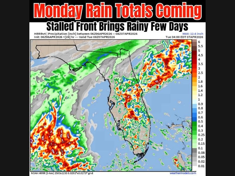
Florida Rainfall Surge Begins Monday as Stalled Front Brings Multi-Day Downpours With Heaviest Totals Targeting Orlando, Tampa and East Coast Cities
FLORIDA — A stalled frontal boundary moving into the peninsula is expected to bring several days of widespread rain beginning Monday, with heavier pockets likely developing across central and eastern parts of the state.
Forecast models show increasing rain chances over the next few days, with some areas potentially picking up multiple inches of rainfall as the system lingers across the region.
Stalled Front Sets Up Extended Rainfall Pattern Across Florida
The approaching front is expected to slow down as it reaches Florida, creating a prolonged period of unsettled weather rather than a quick-moving system.
This setup allows rain bands to repeatedly develop and move across the same areas, increasing the potential for higher rainfall totals over time. The pattern is expected to continue into Tuesday and Wednesday, extending the window for steady and occasionally heavy rain.
Heaviest Rainfall Likely Across Central and Eastern Florida
Model data indicates that the east side of Florida could see significantly more rainfall compared to the western side of the state.
Cities along and east of the Interstate 95 corridor, as well as central Florida locations like Orlando, may experience more consistent and heavier rain bands. Localized pockets could see several inches of rain, especially where storms repeatedly track over the same areas.
Gulf Coast and Western Florida May See Lower Totals
In contrast, parts of western Florida, including areas closer to the Gulf Coast, may remain on the lighter side of the rainfall distribution.
While showers are still expected across these regions, totals may be lower compared to the eastern half of the peninsula. This uneven rainfall pattern highlights how localized heavy rain zones could develop during this multi-day event.
Isolated Heavy Downpours Could Lead to Localized Flooding
Even though widespread flooding is not guaranteed, isolated areas could see heavier bursts of rain that lead to temporary water accumulation.
Urban areas and locations with poor drainage will be more vulnerable if repeated storms pass over the same spot. Residents should remain aware of changing conditions, especially during periods of heavier rainfall.
Rain Chances Continue Into Midweek With Uncertain Totals
The overall pattern suggests continued rain chances through midweek, but exact totals will depend on how the front behaves and where storms repeatedly develop. Small shifts in the system could lead to big differences in rainfall amounts between neighboring areas.
This makes it important to monitor updates as the situation evolves. As this rainy pattern begins across Florida, are you seeing heavier showers in your area or just light rain so far? Share your updates with us at SaludaStandard-Sentinel.com.