Illinois, Wisconsin, Michigan and Indiana Face Elevated Tornado Risk as TORCON 5 Issued With Chicago Suburbs in High Impact Zone
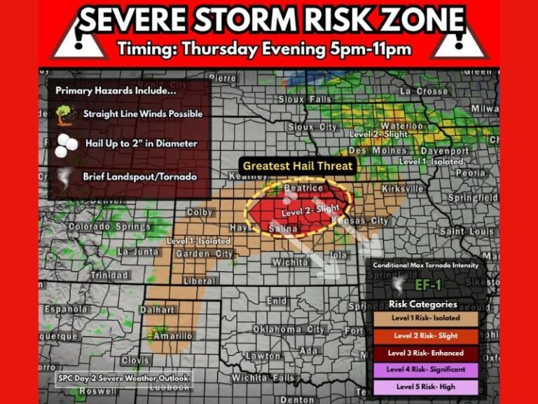
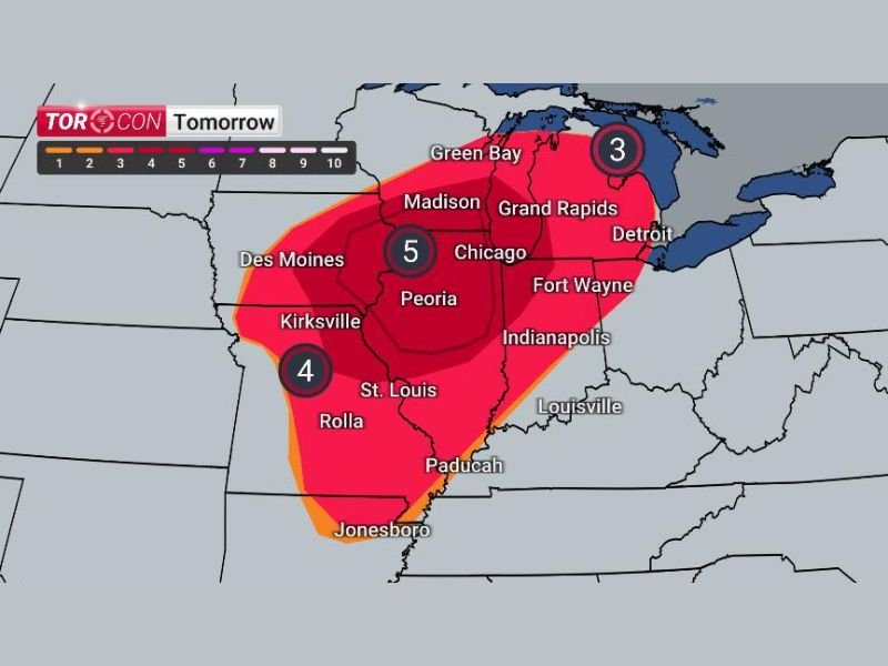
ILLINOIS — A significant increase in tornado risk has been issued across parts of the Midwest, with a TORCON level 5 now in place for Thursday, signaling a heightened concern for severe weather, including tornado development.
The updated outlook places millions of residents, including those in and around the Chicago metro area, under a more serious threat as conditions align for storm formation.
TORCON 5 Highlights Growing Tornado Potential
On the TORCON scale, which ranges from 1 to 10, a level 5 represents a moderate but notable tornado risk, indicating that atmospheric conditions are becoming increasingly supportive of rotating storms.
Forecasters estimate that approximately 9 million people fall within this elevated risk zone, including the western suburbs of Chicago, where storm development could become particularly active. This level does not guarantee tornadoes, but it significantly raises the likelihood of storms capable of producing them.
Multi-State Risk Zone Expands Across Midwest
The risk area extends well beyond Illinois, covering a broad region that includes:
- Southern Wisconsin, including Madison
- Western and central Michigan, including Grand Rapids
- Northern Indiana, including areas near Fort Wayne
- Eastern Iowa and parts of Missouri
Cities such as Chicago, Peoria, Indianapolis, and Detroit are all within or near zones of concern, highlighting the widespread nature of this setup.
Core Risk Centered Over Illinois and Surrounding Areas
The highest concentration of risk appears centered over Illinois, particularly near Peoria and extending toward the Chicago region. This area is marked by the TORCON 5 designation, surrounded by slightly lower but still concerning levels across neighboring states.
Areas farther south and west, including parts of Missouri, are also under elevated concern, with TORCON values around 4 indicating additional potential for storm activity.
Meanwhile, northern zones into Michigan show a slightly lower but still notable risk level.
Conditions Favor Storm Development on Thursday
The setup suggests that storm ingredients are coming together, including instability, wind shear, and moisture—all key factors needed for tornado-producing storms.
As the day progresses Thursday, storms could begin to form and organize, with the potential to strengthen into supercells capable of producing tornadoes, large hail, and damaging winds.
The exact timing and intensity will depend on how storms initiate, but the environment is clearly supportive of severe weather.
Residents Urged to Stay Alert Ahead of Developing Threat
With a large population under the risk zone, officials are encouraging residents to:
- Stay updated on weather alerts throughout Thursday
- Review tornado safety plans in advance
- Identify safe shelter locations in homes or workplaces
Even areas outside the highest TORCON zone could still see strong storms, making it important for the entire region to remain weather-aware.
This developing situation will continue to be monitored closely as Thursday approaches, and residents across Illinois, Wisconsin, Michigan, Indiana, Iowa, and Missouri are encouraged to stay connected with updates on SaludaStandard-Sentinel.com.