Georgia and Southeastern United States Face June Like Heat Surge Up to 20 Degrees Above Normal With Moist Gulf Air Bringing Isolated Showers
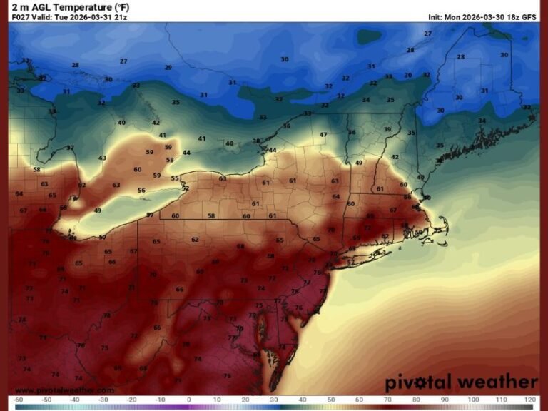
GEORGIA — A significant warm-up is expected across Georgia and much of the Southeast as a strong high-pressure system settles off the East Coast, bringing temperatures that could climb as much as 20 degrees above normal.
This pattern will also pull in moisture from the Atlantic Ocean and Gulf, creating humid conditions along with the chance for scattered showers, though no severe storms are expected.
High Pressure System Driving Warm and Humid Conditions
A large area of high pressure positioned off the East Coast is playing a major role in this setup, helping to funnel warm air northward into Georgia and surrounding states.
This circulation pattern is drawing in moisture from both the Atlantic and Gulf, increasing humidity levels across the region. As a result, the Southeast will experience a more summer-like feel, even though the calendar still suggests early spring.
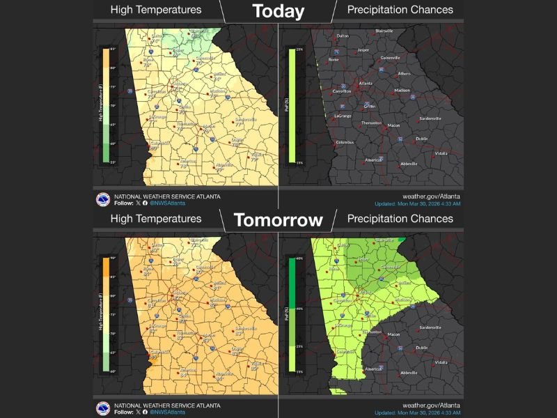
Temperatures Could Climb Up to 20 Degrees Above Normal
Forecast models indicate that temperatures across Georgia could reach levels typically seen in June, running significantly above seasonal averages.
Many areas are expected to see highs well into the upper 70s and 80s, with some spots pushing even higher depending on sunshine and cloud cover. This kind of temperature jump can catch residents off guard, especially after more typical spring conditions.
Moisture Increase May Trigger Isolated Showers and Storms
With increased humidity in place, the atmosphere may support the development of scattered showers or even a few thunderstorms.
These will likely be isolated and short-lived, developing mainly during peak heating hours or overnight as moisture builds. Rain chances will vary from day to day, with some areas staying dry while others see brief periods of rain.
No Severe Weather Expected Despite Active Pattern
While thunderstorms are possible, forecasters do not expect severe weather with this setup. The main impacts will be heat and humidity rather than damaging winds or organized storm systems. This reduces the risk of widespread disruptions but still calls for awareness during outdoor activities.
Warm Pattern Expected to Continue Into the Following Day
The warm and humid conditions are expected to persist into the next day, with similar temperature trends and scattered rain chances continuing. This extended pattern means residents will experience multiple days of above-normal warmth before any significant change occurs.
Staying hydrated and prepared for shifting weather conditions will be important as the pattern holds. Stay informed and share your local conditions or experiences by visiting SaludaStandard-Sentinel.com.