Colorado Front Range and Palmer Divide Face Strong Low Level Jet Winds With 40 MPH Gusts and Wind Chills Dropping Into Teens Overnight
COLORADO — Strengthening low-level jet winds are beginning to impact parts of eastern Colorado, bringing increasing wind speeds and sharply colder wind chills, particularly along the Palmer Divide.
Meteorologists report that southerly winds are intensifying across the region, with gusts reaching up to 40 mph in some areas. These winds are not only creating breezy conditions but are also contributing to rapidly dropping wind chill values overnight.
Low Level Jet Winds Strengthening Across Eastern Colorado
The current pattern is being driven by a low-level jet, a fast-moving ribbon of air just above the surface that can enhance wind speeds at ground level.
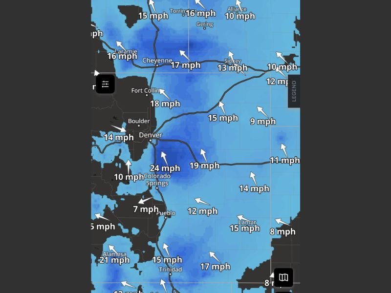
Wind observations across the region show sustained speeds generally ranging from 10 to 25 mph, with stronger pockets near Colorado Springs and surrounding areas. Gusts, however, are significantly higher and are expected to peak overnight. Cities along the Front Range, including Denver, Boulder, and Fort Collins, are already experiencing increasing winds as the system strengthens.
Strongest Impacts Expected Along Palmer Divide
The Palmer Divide, a higher elevation ridge running between Denver and Colorado Springs, is expected to see some of the most noticeable impacts from this wind event.
Due to elevation and exposure, winds in this area tend to accelerate more efficiently, leading to stronger gusts and colder perceived temperatures. Wind chills in these locations could drop into the teens overnight, creating a much colder feel than actual air temperatures. Residents in this region may notice rapidly changing conditions, especially after sunset as winds continue to increase.
Gusts Up to 40 MPH Could Create Travel and Comfort Issues
Wind gusts approaching 40 mph can make travel more difficult, particularly for high-profile vehicles on exposed roadways. Blowing dust and debris may also reduce visibility in some locations.
In addition, strong winds can make outdoor conditions uncomfortable and potentially hazardous, especially during nighttime hours when temperatures are lower. Loose outdoor objects may be displaced, and residents are encouraged to secure items ahead of peak wind periods.
Why Wind Chills Are Dropping So Quickly
Even though actual temperatures may not be extremely cold, the combination of steady winds and cooler air is significantly lowering the “feels-like” temperature.
Wind removes heat from the body more quickly, which is why conditions can feel much colder than what thermometers indicate. This effect is most noticeable in open and elevated areas where winds are strongest. As a result, wind chills dropping into the teens are possible, particularly along the Palmer Divide and nearby regions.
Conditions Expected to Persist Overnight
The low-level jet is expected to remain active through the overnight hours before gradually weakening. Winds may begin to ease slightly by early morning, but breezy conditions could still linger into the day.
This type of setup is common during transitional weather periods, where shifting pressure systems create strong wind gradients across the region. Residents are advised to prepare for a windy and colder-than-expected night, especially in exposed areas.
Have you noticed stronger winds or colder conditions where you are? Share your experience and stay updated with the latest weather alerts at SaludaStandard-Sentinel.com.