Colorado, Wyoming and Nebraska Brace for Overnight Freeze as Temperatures Drop Into 20s and Low 30s Threatening Early Spring Plants
COLORADO, WYOMING, NEBRASKA — A sharp drop in overnight temperatures is expected across parts of the central Rockies and High Plains, with lows falling into the 20s and low 30s, raising concerns for gardeners and early spring planting.
Forecast models indicate that a widespread cold snap will settle in overnight, bringing conditions cold enough to trigger frost and freeze concerns across multiple states. The coldest pockets could dip into the mid-to-upper 20s, particularly in elevated and rural areas.
Widespread Low Temperatures Expected Across the Region
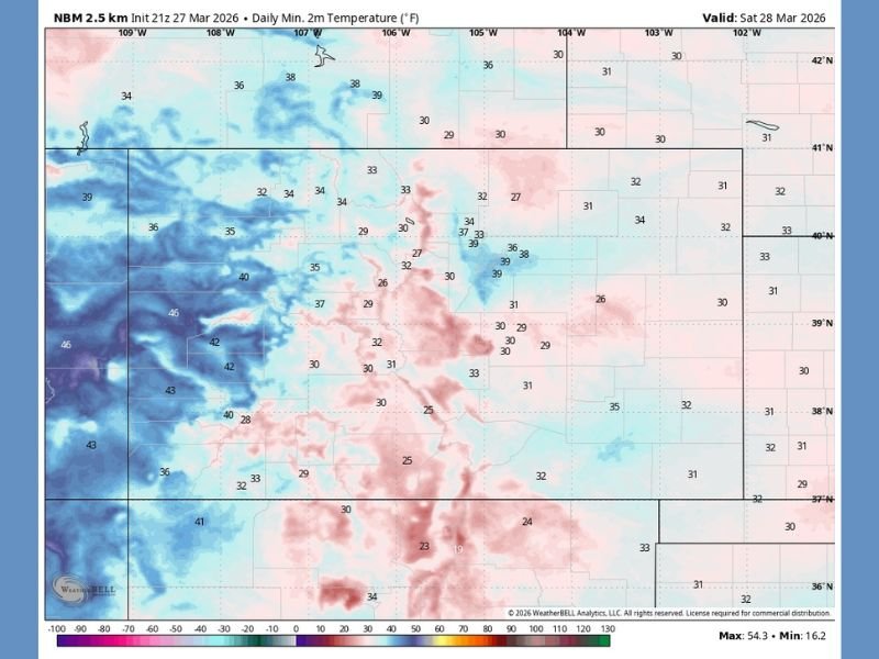
The latest temperature guidance shows a broad area of sub-freezing or near-freezing temperatures stretching across Colorado and into portions of Wyoming and Nebraska.
Many locations are expected to see overnight lows between 25°F and 32°F, while surrounding areas may hover in the low to mid-30s. These conditions are cold enough to damage sensitive vegetation, especially plants that have already begun early spring growth.
Meteorologists note that while late-season cold snaps are not uncommon, the timing during active planting season increases the potential for impact.
Why This Freeze Could Be Problematic for Gardeners
As warmer temperatures in recent weeks encouraged early planting, many gardens are now vulnerable to sudden cold exposure. Tender plants, budding trees, and newly planted crops are especially at risk when temperatures drop below freezing.
Even a brief freeze can damage plant cells, leading to wilting, discoloration, or long-term harm. Areas that experience calm winds and clear skies overnight are most susceptible to frost formation, which can further intensify the impact.
Residents who have already begun planting are being advised to take precautions to protect their vegetation.
Cold Air Pattern Driving the Temperature Drop
This cold snap is being driven by a surge of cooler air settling into the region, likely associated with a passing weather system and clearing skies behind it.
As skies clear overnight, heat escapes more efficiently from the surface, allowing temperatures to fall quickly. This process, combined with relatively dry air, creates ideal conditions for rapid cooling after sunset.
The pattern is typical for early spring, when fluctuating temperatures can bring both mild days and sudden cold nights within a short timeframe.
Freeze Risk Highest in Rural and Elevated Areas
Not all areas will experience the same level of cold. Rural locations, valleys, and higher elevations are more likely to see the lowest temperatures due to reduced urban heat and better radiational cooling conditions.
Cities may remain slightly warmer, but even urban areas could still approach freezing, especially in sheltered spots. Gardeners and residents in colder-prone zones should remain especially cautious as temperatures approach critical thresholds overnight.
Precautions Urged Ahead of Overnight Cold
With temperatures expected to dip into freeze territory, residents are encouraged to take protective measures such as covering plants, bringing potted vegetation indoors, and ensuring irrigation systems are safeguarded.
While the cold snap is expected to be relatively brief, its impact could be significant for early-season growth. As spring continues to fluctuate between warm and cold patterns, staying prepared for sudden changes remains essential.
Have you started planting this season, or are you holding off due to unpredictable weather? Share your experience and tips with the community at SaludaStandard-Sentinel.com.