Texas, Oklahoma, Arkansas, Missouri, Illinois, Indiana, Kentucky and Tennessee in Focus as Early April Pattern Shift Signals Active Severe Storm Track
UNITED STATES — A significant pattern shift is expected as April begins, with weather models pointing toward a more active storm setup across the central United States, including Texas, Oklahoma, Arkansas, Missouri, Illinois, Indiana, Kentucky, and Tennessee.
This transition could mark the start of a more consistent severe weather pattern, with repeated storm systems developing across the same general region.
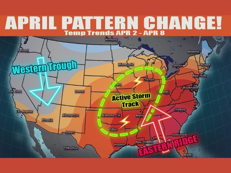
Western Trough and Eastern Ridge Driving Storm Setup
Forecast data indicates a developing western trough over the western United States combined with a strengthening ridge across the eastern part of the country. This setup is widely known for creating favorable conditions for severe weather.
As warm, moist air surges northward from the Gulf and interacts with cooler air from the west, the environment becomes increasingly unstable. This clash of air masses is a key ingredient for thunderstorm development.
The positioning of these features places the central U.S. directly in the path of what meteorologists often call an “active storm track.”
Central States Highlighted for Repeated Storm Activity
The region stretching from Texas through Oklahoma and into Arkansas, Missouri, Illinois, Indiana, Kentucky, and Tennessee is expected to be the primary zone for increased storm activity.
Cities including Dallas, Oklahoma City, Memphis, St. Louis, Chicago, and surrounding areas fall within this corridor, meaning multiple rounds of storms could impact both urban and rural areas.
This pattern suggests that storms may not be limited to a single day but could occur repeatedly over several days as systems move along the same track.
Confidence Growing in Pattern but Timing Still Uncertain
Meteorologists note that confidence in the overall pattern change is increasing, meaning there is strong agreement among models about the general setup.
However, the exact timing and placement of individual storm systems remain uncertain. Small shifts in the pattern could change which specific areas see the strongest impacts on any given day.
Despite this uncertainty, the consistency of the broader pattern highlights the need for early awareness across the highlighted states.
Warmth in the East and Instability Fuel Storm Potential
The eastern ridge will help push warmer temperatures into the eastern United States, creating a strong contrast with cooler air moving in from the west.
This temperature contrast enhances instability in the atmosphere, which is a critical factor in the development of severe thunderstorms.
As a result, storms forming along this boundary could become strong, with the potential for damaging winds, hail, and possibly tornadoes depending on how conditions evolve.
Early April Could Mark Start of More Active Severe Weather Period
The transition into April often brings an increase in severe weather activity, and this setup appears to align with that seasonal trend. The presence of a well-defined storm track raises the possibility of multiple impactful weather events.
Residents across the central U.S. should begin monitoring forecasts closely as this pattern develops, especially as more detailed short-term predictions become available.
If you live in any of these states, share how you’re preparing for the potential shift in weather patterns by visiting SaludaStandard-Sentinel.com.