Tornado Warned Supercell Turns Green With Large Hail Near Gravity Iowa as Major Tornado Outbreak Threat Looms Across Nebraska Iowa and South Dakota Tomorrow
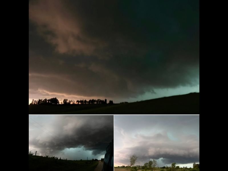
GRAVITY, IA — A powerful tornado warned supercell near Gravity, Iowa turned green and produced large hail while making multiple attempts at generating a significant tornado during active storm chase operations across the region. The supercell, which was the highlight of an already active storm chase day that also included a historic haboob event along I-70 in Kansas, sets the stage for an even more significant tornado outbreak threat forecast for Nebraska, Iowa, and South Dakota in the coming day.
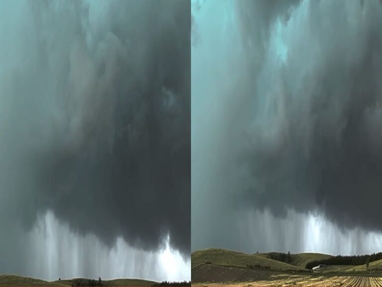
Tornado Warned Supercell Near Gravity Iowa Produces Large Hail and Green Sky
Storm chase operations initially targeted northeast Kansas on this active severe weather day, but storms failed to develop as anticipated across that region, prompting a northward repositioning toward a tornado warned supercell near Gravity, Iowa. The storm produced large hail and displayed the distinctive green sky phenomenon, a visual indicator of an extremely deep and hail laden storm cell with intense updraft characteristics that meteorologists associate with the most severe and dangerous supercell thunderstorms.
The green coloration of the sky during this supercell event results from the interaction of reddish evening sunlight filtering through an atmosphere heavily loaded with large hail and water droplets at altitude, producing the eerie and visually striking green tint that experienced storm observers recognize as a signature of a particularly intense storm core.
Storm Made Multiple Attempts at a Larger Tornado During Its Lifespan
While a confirmed tornado was missed by approximately ten minutes during the chase near Gravity, the supercell made multiple subsequent attempts at producing a much larger and more significant tornado throughout its tracked lifespan across Iowa. These repeated tornado attempts reflect the highly favorable atmospheric conditions in place across the region, with the storm repeatedly organizing and cycling in a pattern consistent with supercells capable of producing strong and long track tornadoes under the right conditions.
The overall storm chase day was described as exceptionally productive across both Kansas and Iowa, with numerous storm targets tracked and an epic haboob dust storm event documented along the I-70 corridor in Kansas adding to what was already a remarkable day of severe weather activity across the Central Plains.
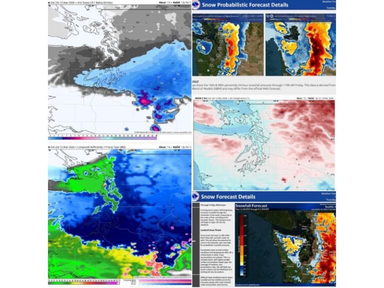
Major Tornado Outbreak Threat Forecast for Nebraska Iowa and South Dakota Tomorrow
Looking ahead, a significant and potentially major tornado outbreak threat is developing for Nebraska, Iowa, and South Dakota for the following day. The atmospheric setup building across the Northern and Central Plains is generating considerable concern among meteorologists and storm observers given the ingredients already in place across the region following the active storm day documented near Gravity and across Kansas.
Residents across Nebraska, Iowa, and South Dakota are strongly urged to monitor forecast updates closely and have their severe weather plans firmly in place well ahead of tomorrow’s developing outbreak threat, as the potential exists for a significant and wide ranging tornado event across all three states.
For continuing coverage of tornado outbreaks and severe storm tracking across the United States, visit SaludaStandard-Sentinel.com.