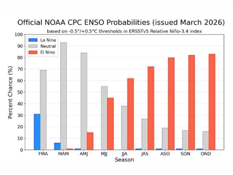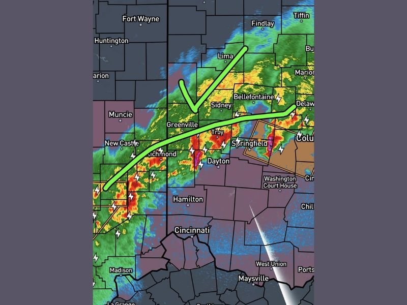
Ohio and Indiana Storm Line Pushes South of Greenville, Dayton and Springfield Late Night as Severe Threat Continues Toward Cincinnati and Maysville
OHIO — A line of severe storms pushed across western and central Ohio late Sunday night, with the threat diminishing north of a defined boundary while continuing farther south toward the Cincinnati region.
The latest late-night update indicates that areas north of the storm line, including parts of western Ohio and eastern Indiana, are beginning to clear, while active warnings and storm activity persist to the south.
Storm Threat Ends North of Greenville and Sidney
Radar imagery shows a clear dividing line stretching across parts of western Ohio, marking where the severe threat has effectively ended for the night.
Communities north of this boundary, including Greenville, Sidney, and areas toward Lima and Findlay, are seeing improving conditions as storms move away.
Meteorologists indicate residents in these northern zones can expect calmer weather overnight as the system continues shifting southward.
Active Storms Continue Near Dayton and Springfield
South of the boundary line, strong to severe storms remain active, particularly around Dayton, Troy, Springfield, and surrounding areas.
Heavy rainfall, frequent lightning, and strong wind gusts continue to be reported as the line pushes southeast.
Some storms in this corridor have shown signs of intensification, prompting continued monitoring and warnings in affected counties.
Severe Risk Extends Toward Cincinnati and Southern Ohio
The most significant concern now shifts toward southern Ohio, including Cincinnati, Hamilton, and areas extending toward Maysville near the Ohio-Kentucky border.
These regions remain in the path of the strongest storms as the system progresses, with the potential for damaging winds and localized flooding.
Residents in these areas are urged to remain alert as conditions can change quickly overnight.
Storm Line Tracking Southeast Through the Region
The overall movement of the storm system is toward the southeast, gradually exiting northern areas while maintaining strength farther south.
This progression is typical of late-night storm systems, where instability shifts and allows storms to persist in southern zones even after weakening to the north.
Emergency managers continue to monitor the system closely as it tracks across state lines.
Residents Encouraged to Stay Alert Overnight
Officials emphasize that even as conditions improve in some areas, the threat is not over for everyone.
Those south of the storm boundary should continue to monitor alerts, keep devices charged, and be prepared for sudden weather changes during the overnight hours.
If you experienced severe weather in your area tonight or are still tracking storms, share your updates with us. Stay connected with SaludaStandard-Sentinel.com for real-time coverage as this storm system continues moving across Ohio and into neighboring regions.