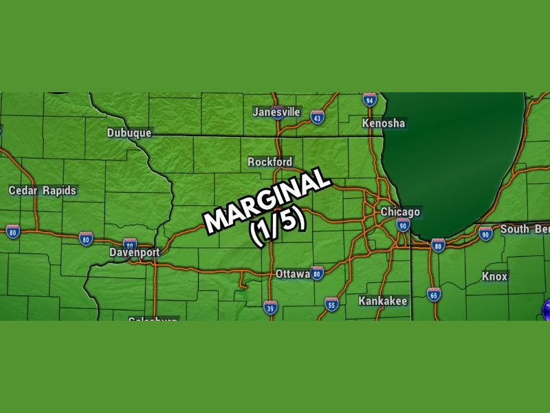
Marginal Severe Weather Risk With Gusty Winds Hail and Torrential Downpours Possible Across Chicago, Rockford, and Northern Illinois Monday Afternoon Through 10 PM
CHICAGO, IL — A fairly strong cold front was forecast to trigger a complex of showers and strong to severe storms across northern Illinois on Monday, with the severe weather threat window running from approximately 4 PM through 10 PM as the front pushed through the region during the late afternoon to early evening hours.
The severe weather risk was rated Marginal at 1 out of 5 across a zone covering Chicago, Rockford, Janesville, Kenosha, and surrounding northern Illinois and southern Wisconsin communities, indicating a low but real chance of isolated severe storm development during the Monday evening timeframe.
Gusty Winds and Hail Represent Primary Hazards
The main severe weather concern with the Monday cold front passage was gusty winds, with hail also possible alongside brief and torrential downpours during the most active portion of the storm complex. No tornado threat was identified with the system at the time of the forecast, keeping the hazard profile focused on wind and hail rather than rotating storm development across the northern Illinois corridor.
The cold front was expected to initiate storm activity to the west during the afternoon hours before the complex reached the Chicago metro and surrounding communities during the very late afternoon to early evening window.
Marginal Risk Zone Covers Northern Illinois Corridor
The Marginal severe weather risk zone encompassed communities across northern Illinois and portions of southern Wisconsin including Chicago, Rockford, Janesville, Kenosha, Davenport, Ottawa, and Kankakee. While the 1 out of 5 risk designation indicated limited severe weather potential, the possibility of gusty winds, hail, and heavy downpours within the 4 PM to 10 PM window warranted awareness for residents across the warned corridor.
Dubuque, Cedar Rapids, and surrounding Iowa communities along the western edge of the risk area also fell within the broader storm complex footprint as the cold front tracked eastward through the region.
Monitoring Continues Through Monday Evening
Residents across the northern Illinois and southern Wisconsin corridor were advised to stay weather aware through the Monday afternoon and evening hours, keep mobile weather alerts active, and be prepared for brief but potentially gusty and hail-producing storm activity as the cold front pushed through the region between 4 PM and 10 PM.
For continuing coverage of severe weather events and critical storm analysis across the United States, visit SaludaStandard-Sentinel.com.