Ohio Overnight Storm Alert: Northwest Ohio Faces Highest Tornado Risk as Powerful Storm Line Targets Cleveland Before Sunrise
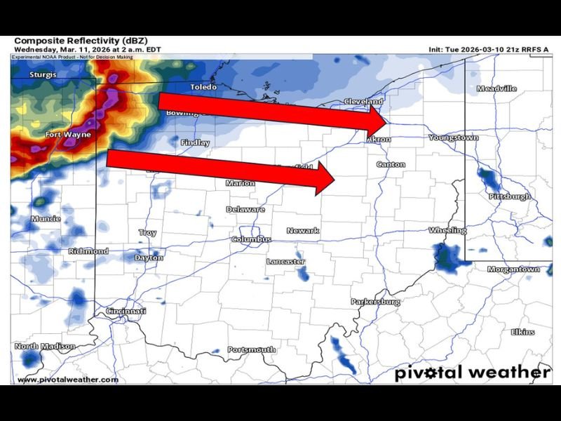
OHIO — Meteorologists are closely monitoring a potentially dangerous overnight severe weather event developing across the Midwest, with a strengthening line of storms expected to move into northwest Ohio during the early morning hours before pushing toward the Cleveland area around sunrise.
Forecast models are showing increasing confidence that a powerful cluster of thunderstorms will intensify overnight, raising concerns about damaging winds, large hail, and the possibility of isolated tornadoes. Because the storms are expected to arrive during the overnight hours when many people are asleep, forecasters warn that the situation could become particularly hazardous for communities in the storm’s path.
Northwest Ohio Identified as Highest Risk Area
Weather experts say the greatest concern is currently focused on northwest Ohio, where atmospheric conditions appear most favorable for stronger storms.
Cities including Toledo, Bowling Green, and Findlay are among the areas that could experience the first impacts as the storm line approaches from the west. Meteorologists say residents in this region should ensure they have multiple ways to receive weather alerts, such as emergency alerts on smartphones or NOAA weather radios.
Storms Could Bring Powerful Winds and Large Hail
As the storm line intensifies overnight, several severe weather hazards may develop.
Forecasters say the strongest storms could produce:
- Damaging wind gusts up to 75 mph
- Large hail
- Heavy rainfall and lightning
- The possibility of a few tornadoes
Storm clusters moving through the region may evolve into a fast-moving line capable of producing widespread wind damage, especially if storms strengthen before reaching Ohio.
Timeline Points to Early Morning Arrival
Model projections indicate the storm line may enter northwest Ohio between approximately 1 a.m. and 2 a.m. After crossing the western portion of the state, the system is expected to continue moving eastward across northern Ohio.
If current projections hold, the storms could approach the Cleveland metropolitan area around 5 a.m., bringing heavy rain and strong winds during the early morning commute hours. Communities across Akron, Canton, and Youngstown could also see storms later in the morning as the system continues eastward.
Overnight Storms Increase Safety Concerns
Forecasters often highlight overnight severe weather events as particularly dangerous because warning messages can be missed while people are asleep.
Emergency officials recommend residents:
- Keep their phones charged and emergency alerts enabled
- Have a weather radio available for overnight warnings
- Identify a safe shelter area in advance
- Be prepared to act quickly if a warning is issued
Storm Strength Still Being Monitored
Meteorologists stress that the exact strength and track of the storms could still change as new forecast data becomes available overnight. However, the latest guidance shows a strong signal for a significant line of storms capable of producing severe weather across parts of Ohio.
Residents across the region are encouraged to stay weather aware and monitor forecasts closely through the night. Stay with SaludaStandard-Sentinel.com for continuing updates as meteorologists track the developing overnight storm threat moving toward Ohio.