Major Severe Weather Setup Emerging for March 10–11 as Storm System Could Bring Tornadoes, Hail and Damaging Winds From Texas to the Mid-Atlantic
UNITED STATES — Meteorologists are closely monitoring a developing weather pattern that could trigger widespread severe storms across a large portion of the United States early next week, with Tuesday and Wednesday emerging as the primary days of concern.
Forecast discussions indicate that a large upper-level trough is expected to move across the country, creating an environment capable of supporting multiple types of severe weather. If current projections hold, the system could bring tornadoes, large hail, damaging winds, and heavy rain across several regions.
While the exact details will continue to evolve over the next few days, forecasters say the overall atmospheric pattern already supports broad storm development across a large geographic area.
Severe Storm Threat Expected to Begin March 10
The first round of potentially severe weather could develop on Tuesday, March 10, as the storm system begins strengthening across the central United States.
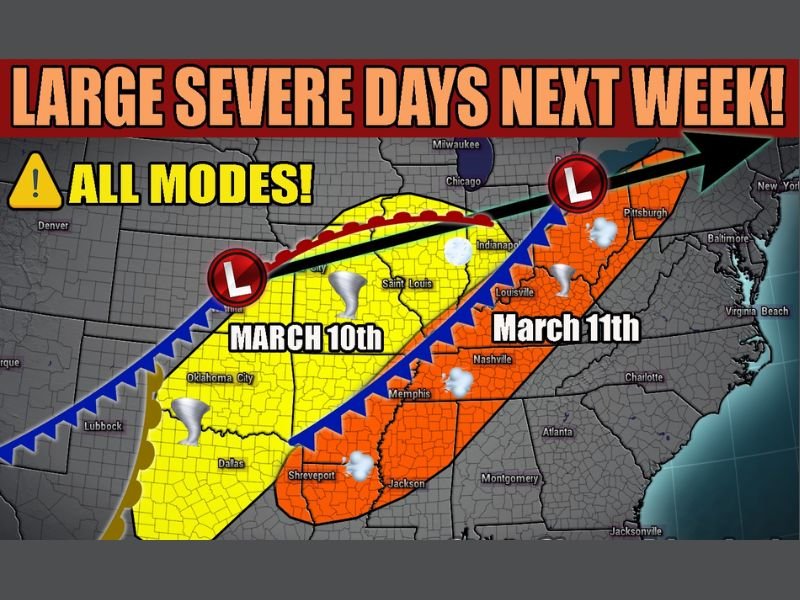
Forecast maps indicate the greatest risk on Tuesday may stretch from north Texas and Oklahoma northeast through Missouri and Illinois, covering cities such as Dallas, Oklahoma City, St. Louis, and Indianapolis.
Warm, moisture-rich air flowing northward from the Gulf of Mexico will likely collide with a strengthening cold front moving east from the Plains. This setup often provides the ingredients necessary for strong thunderstorms to develop.
Meteorologists say storms forming within this zone could produce all modes of severe weather, including tornadoes and large hail.
Storm System Expected to Shift East on March 11
As the system continues moving east, the severe weather risk is expected to expand on Wednesday, March 11 across parts of the Mississippi Valley, Tennessee Valley, and Mid-Atlantic.
Forecast projections show a corridor of storm activity potentially extending from Louisiana and Mississippi northeast through Tennessee, Kentucky, and into Pennsylvania.
Cities including Jackson, Memphis, Nashville, Louisville, and Pittsburgh could be within the path of strong storms as the system pushes across the region.
These storms may again bring the potential for damaging winds, hail, heavy rain, and isolated tornadoes depending on how atmospheric conditions evolve.
Forecasters Emphasize Uncertainty but Growing Concern
Meteorologists caution that it is still several days away from the event, meaning the exact placement of the highest risk areas may shift as new data becomes available.
However, the large-scale weather pattern developing across the United States is one that historically supports widespread thunderstorm outbreaks across multiple states.
Weather experts say additional forecast updates over the coming days will help refine which communities face the highest threat.
Residents Across Multiple States Urged to Stay Weather Aware
Because the potential severe weather could span a large portion of the country, residents from the Southern Plains to the Midwest and Mid-Atlantic are encouraged to monitor forecasts closely through the weekend.
Having multiple ways to receive weather alerts and reviewing severe weather safety plans can help communities prepare if the storm system intensifies.
Meteorologists say early awareness is critical whenever a large, multi-day severe weather setup begins to take shape.
Stay with Saluda Standard-Sentinel for continuing updates as meteorologists refine the forecast and track this developing storm system heading into March 10 and March 11.