North Carolina Set for Massive Spring Warmup After Brief Chill, Highs Climbing Into 70s and Near 80 by Late Next Week
NORTH CAROLINA — A dramatic shift toward spring-like weather is expected across the state, with forecasters calling for a brief weekend warmup, a short cooldown early next week, and then a much larger temperature surge lasting into next weekend and possibly beyond.
Meteorologists indicate high confidence in above-average temperatures beginning Wednesday as the overall weather pattern changes. A more sustained spring setup is forecast to take hold, bringing warmer days and increased sunshine across much of the state.
Brief Cooldown Before Major Pattern Shift
According to the latest outlook, North Carolina will experience a temporary warmup this weekend before colder air returns Monday and Tuesday. This short-lived chill will not last long.
By midweek, a significant pattern change is expected. Forecasters say the atmosphere will reorganize in a way that promotes warmer air spreading across the region. This transition is described as a true spring-like shift rather than a quick temperature spike.
High Confidence in Above-Average Temperatures
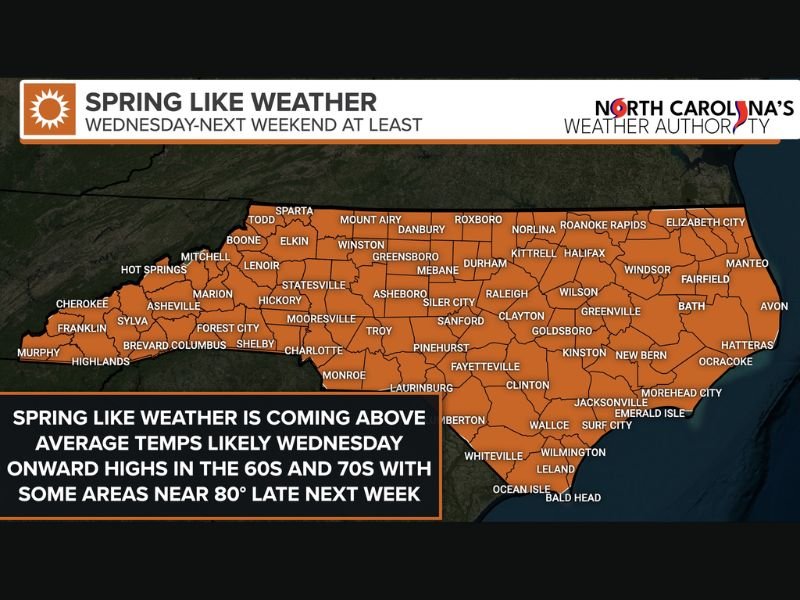
Starting Wednesday, temperatures are projected to climb well above seasonal averages. Most areas across the state are expected to see highs in the 60s and 70s on many days.
Some inland communities could approach 80 degrees at times late next week. The warming trend is also expected to bring more sunshine, reinforcing the feel of early spring.
Weather analysts emphasize that confidence is strong this time, with the warm pattern likely to persist into next weekend and potentially longer if the broader atmospheric setup remains locked in place.
Sunshine Returns — But So Does Pollen
Along with warmer air, clearer skies and brighter afternoons are anticipated statewide. However, forecasters also warn that pollen levels are expected to rise as temperatures increase.
Residents sensitive to seasonal allergies may begin noticing symptoms as trees and early vegetation respond to the warmer stretch.
What This Means for the Region
The upcoming shift signals a noticeable break from winter-like variability. While brief cool spells are still possible this time of year, the overall trajectory suggests that spring is beginning to take hold across North Carolina.
With daytime highs regularly climbing into the 60s and 70s — and even nearing 80 degrees in some inland areas — outdoor activity is likely to increase heading into late next week.
Are you ready for the warmer days ahead, or do you prefer cooler early-spring weather? Share your thoughts and how you’re preparing for the seasonal shift at SaludaStandard-SSentinel.com.