Potential Increases for Significant Winter Storm as Hazardous Cold and Heavy Snow Threaten Texas, Louisiana, Mississippi, Alabama, Georgia, Tennessee, Kentucky, North Carolina, Virginia, and New York
UNITED STATES — Forecasters are warning that the potential is increasing for another significant winter storm to impact large portions of the eastern United States this coming weekend, as dangerously cold air remains locked in place across multiple regions.
Weather models show hazardous cold conditions spreading from parts of Texas and Louisiana through the Deep South and into the Ohio Valley and East Coast, while some areas could also see heavy snow develop as the system strengthens. While exact impacts are still coming into focus, meteorologists caution that the setup is becoming more concerning with each update.
Hazardous Cold Expected Across Multiple Regions
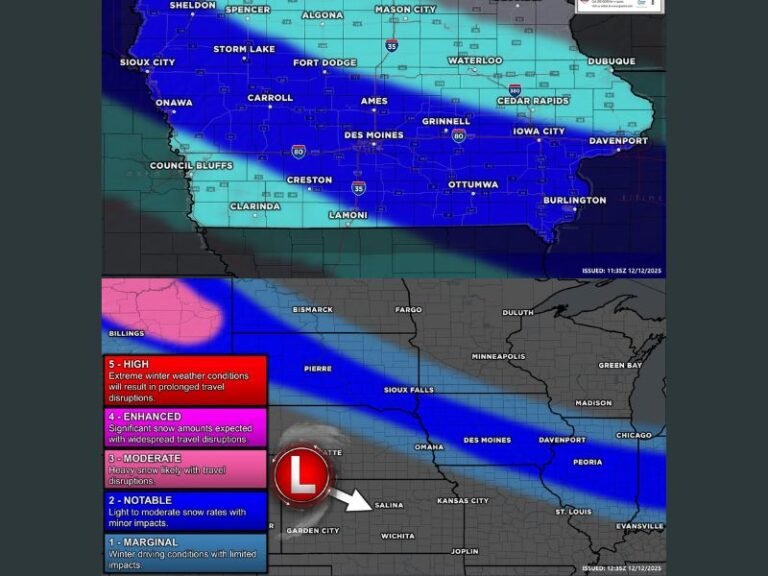
Large portions of Texas, Louisiana, Mississippi, Alabama, Georgia, Tennessee, Kentucky, North Carolina, and Virginia are forecast to experience hazardous cold between January 29 and February 2, according to the latest outlooks. Temperatures in many of these areas could drop 20 to 30 degrees below seasonal averages, creating dangerous conditions for anyone exposed to the cold.
States across the Deep South, including Alabama, Georgia, and Mississippi, may experience prolonged periods of sub-freezing temperatures, a situation that can stress power systems, freeze pipes, and create travel hazards.
Heavy Snow Possible Along the East Coast and Northeast
In addition to the cold, heavy snow is possible along parts of the East Coast, particularly around January 31 into February 1. Forecast guidance highlights portions of North Carolina’s coastal plain and parts of the Northeast, including New York, as areas to watch closely for accumulating snowfall.
While snow placement and totals remain uncertain, the presence of entrenched cold air increases the risk that any storm developing along the coast could produce impactful winter weather rather than rain.
Storm Pattern Raises Nor’easter Concerns
Meteorologists are also monitoring a storm pattern that could be favorable for a Nor’easter forming along the East Coast. While forecasters stress that this scenario is not locked in, the combination of cold air and an active jet stream means the risk cannot be ignored.
Even a modest shift in storm track could significantly change impacts, potentially expanding snowfall or increasing wind-driven hazards in coastal and inland areas.
Why Forecast Confidence Is Still Limited
Forecasters caution that it is still too early to determine exact impacts, including snowfall totals or which communities may be hit hardest. Small changes in storm timing or track could dramatically alter outcomes, especially when cold air is already in place.
Residents are urged to stay updated with daily forecasts as confidence improves and watches or advisories may be issued later in the week.
What Residents Should Do Now
Officials recommend preparing for dangerously cold temperatures, including checking heating systems, insulating pipes, and planning for potential travel disruptions. Those in snow-prone regions should review winter safety plans and ensure emergency supplies are ready.
Weather officials emphasize that early awareness is key, even before precise details are confirmed.
As always, what are your thoughts on this developing winter threat? Share your experience with extreme cold or winter storms, and join the conversation at SaludaStandard-Sentinel.com.