Texas Weather Alert: Rain and Thunderstorms Expected Across Houston, Galveston, and Victoria Wednesday Morning
HOUSTON, TX — A rainy weather system is moving across Southeast Texas, bringing moderate to heavy rain and isolated thunderstorms late Tuesday night into Wednesday morning. Meteorologists say the disturbance will result in widespread wet roads and slippery conditions for commuters in and around the Houston metro area.
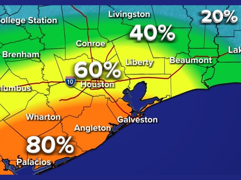
According to ABC13 AccuWeather, rain chances will vary across the region — with Houston seeing about a 60% chance, Galveston around 70%, and Victoria and Palacios reaching as high as 80%.
Rain Spreading Overnight into Wednesday
Forecasters say the disturbance will move northeast across the Texas Gulf Coast, with rain developing late Tuesday and continuing through Wednesday morning.
“We’re looking at a few rumbles of thunder along with plenty of wet streets for the morning drive,” meteorologists said Tuesday evening. “While severe weather is not expected, pockets of heavier rainfall could slow down commuters across the Houston area.”
Areas to the north, including College Station, Conroe, and Livingston, are expected to see lower rain chances, ranging from 20% to 40%, while coastal zones could experience brief downpours before conditions improve by mid-afternoon.
Morning Commute Impacts
Drivers in Houston, Sugar Land, and The Woodlands should prepare for slick roads and reduced visibility, particularly along the I-10 corridor and near Galveston Bay. Morning temperatures will stay in the upper 50s to low 60s, with steady south winds adding to the damp feel.
Rain Chances by Area:
- Houston: 60% chance of showers and isolated thunder.
- Galveston: 70% chance of steady rain, tapering off by noon.
- Victoria and Palacios: 80% chance of rain, with potential for heavy bursts.
- Liberty and Beaumont: 30–40% chance of light showers.
- College Station: 20% chance, mainly drizzle.
What to Expect Through Midweek
The system will move east into Louisiana by Wednesday evening, followed by clearing skies and slightly cooler, drier air for Thursday. Highs Wednesday are forecast to reach the mid-60s, with nighttime lows dipping into the upper 40s once the rain exits.
“By Wednesday afternoon, clouds will begin to break up, and most areas will start drying out,” meteorologists said. “But the early morning drive will be wet and slow, especially south of I-10.”
Safety Tips for Drivers
- Allow extra travel time Wednesday morning.
- Use headlights and reduce speed on wet roads.
- Watch for ponding in low-lying areas or near construction zones.
Forecasters expect no major flooding, but localized water buildup could occur in areas with poor drainage, particularly near Wharton, Angleton, and Galveston Island.
For ongoing weather coverage and updates throughout the week, follow SaludaStandard-Sentinel.com.