Weakening Rain Showers Gusty 30 MPH Winds and Rumbles of Thunder to Move Through Indiana and Ohio After 10 PM as Cold Front Tracks Through Overnight May 12 Into May 13
DAYTON, OH — A cold front is set to push weakening rain showers, gusty winds exceeding 30 miles per hour, and a few rumbles of thunder through Indiana and Ohio after 10 PM on May 12 continuing into May 13, with no severe weather expected across the immediate area though better thunderstorm chances exist northwest of the region as the front advances through the overnight hours.
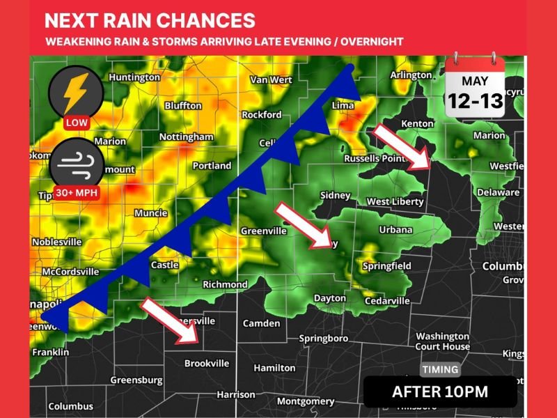
Cold Front Arriving After 10 PM With Rain and Wind
The approaching cold front will deliver its rain and storm activity to the Indiana and Ohio region after 10 PM, making the overnight hours the primary window of impact for communities across the corridor. Radar imagery shows the frontal boundary advancing southeastward with the blue cold front symbol clearly depicted along a line from the Indianapolis area through Richmond and into southwestern Ohio, with shower and storm activity concentrated ahead of and along the frontal boundary.
Communities including Indianapolis, Dayton, Springfield, Urbana, Sidney, and surrounding areas all fall within the path of the advancing rain and wind event during the overnight May 12 into May 13 timeframe.
Gusty Winds the Most Notable Hazard Overnight
With no severe weather expected, the most significant hazard associated with this frontal passage is gusty winds exceeding 30 miles per hour accompanying the rain bands as they push through the region overnight. Gusts of this magnitude can create briefly hazardous driving conditions, knock down small branches, and affect any unsecured outdoor items across communities in the direct path of the frontal boundary during the late night and early morning hours.
Residents should secure any outdoor furniture or lightweight objects before the front arrives after 10 PM across Indiana and Ohio.
Thunder Possible but Severe Weather Not Expected
A few rumbles of thunder cannot be ruled out across portions of the warned corridor as the frontal boundary pushes through overnight, though forecasters are clear that severe weather is not expected across the immediate Indiana and Ohio area. The better thunderstorm chances with this system are positioned northwest of the region, where stronger storm activity is more likely as the cold front interacts with more favorable atmospheric conditions earlier in its eastward progression.
Residents across Indianapolis, Dayton, and surrounding communities can expect conditions to clear progressively behind the front as it exits the region during the May 13 morning hours.
For continuing coverage of severe weather events and critical storm analysis across the United States, visit SaludaStandard-Sentinel.com.