Thunderstorm Activity Rapidly Increasing Along Colorado I-25 Corridor and Raton Mesa Near Trinidad With Palmer Divide Foothills at Elevated Risk Thursday Evening
TRINIDAD, CO — High resolution forecast models are tracking a significant increase in thunderstorm activity across the Colorado Front Range and foothills corridor Thursday evening, with storms already verifying near the Raton Mesa close to Trinidad and additional development expected to intensify across the I-25 corridor northward through the Palmer Divide area as upslope flow increases from the east through the overnight hours.
Storms Already Firing Near Raton Mesa
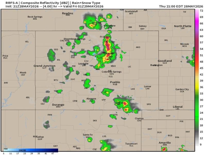
The RRFS-A composite reflectivity forecast valid for Friday at 1:00 AM EDT shows a well-developed cluster of thunderstorm activity positioned near Trinidad and the Raton Mesa, with high reflectivity values indicating intense precipitation cores already confirmed in the area matching what multiple high resolution models had been advertising for the evening hours.
The Raton Mesa region near Trinidad sits at an elevation and geographic position that makes it particularly susceptible to upslope-driven thunderstorm initiation, where easterly winds are forced up the terrain and provide the lift necessary to trigger convective development even when larger scale atmospheric forcing remains modest.
I-25 Corridor and Palmer Divide in the Crosshairs
Beyond the activity already underway near Trinidad, high resolution models are in strong agreement that thunderstorm coverage will expand northward along and near the I-25 corridor over the next several hours, with communities in and north of the Palmer Divide area facing an increasing storm threat as the evening progresses.
The Palmer Divide, a subtle but meteorologically significant topographic feature between Colorado Springs and the Denver metropolitan area, is a well-known focal point for thunderstorm initiation and intensification during upslope flow events, and Thursday evening’s easterly upslope increase creates precisely the conditions that have historically supported rapid storm development along this zone.
Denver Metro Area Monitoring the Situation
Radar imagery shows intense storm cores already present in the Fort Collins to Denver corridor, with deep red and yellow reflectivity values indicating heavy precipitation and potentially dangerous lightning activity affecting the northern Front Range metropolitan communities during the Thursday evening hours.
Residents across the Denver metro area, Boulder County, and communities along the northern I-25 corridor are advised to monitor storm conditions closely given the active radar presentation already underway across the region.
Outdoor Plans Require Caution Tonight
Anyone with outdoor evening plans across the Colorado Front Range foothills and I-25 corridor is strongly urged to have a weather safety plan in place before heading out Thursday evening.
Thunderstorms in the Colorado foothills can develop and intensify rapidly, producing dangerous lightning, heavy rainfall, and gusty winds with limited advance notice, making real-time weather awareness essential for anyone spending time outdoors across the affected zone tonight. For continuing coverage of severe weather developments and Front Range storm activity across the United States, visit SaludaStandard-Sentinel.com.