Missouri Storm Initiation Forecast Near St. Joseph Around 3 to 4 PM Friday as High Resolution Models Signal Widespread Severe Weather Development
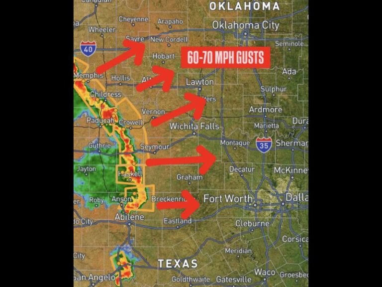
MISSOURI — High resolution weather models are pinpointing St. Joseph, Missouri as a key initiation point for Friday’s severe weather outbreak, with storm development forecast to begin in the area around 3 to 4 PM. The hirez model data shows a broad corridor of intense storm cells firing across Missouri, Kansas, Nebraska, and into Iowa and Illinois as the afternoon heating hours fuel rapid thunderstorm development across the entire region.
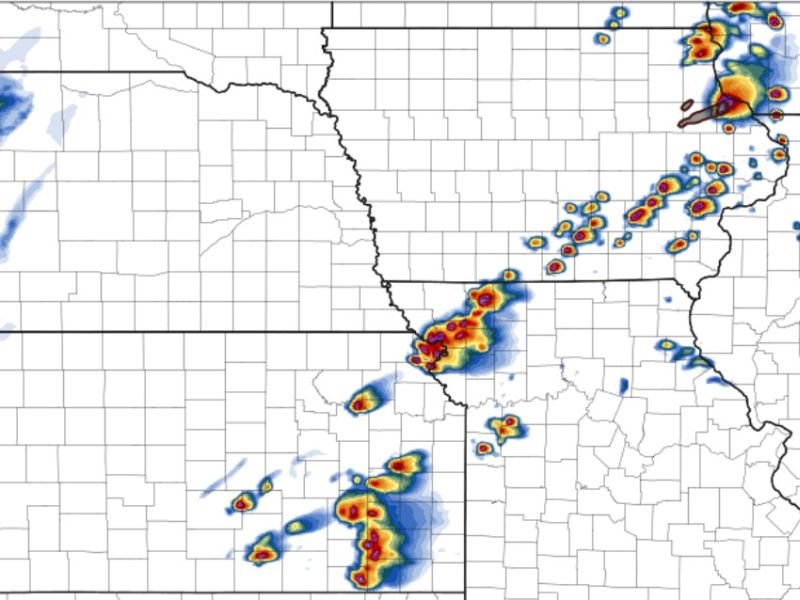
Radar simulation imagery showed concentrated areas of extreme reflectivity values developing near St. Joseph before spreading outward across a wide swath of the central United States throughout Friday afternoon and evening.
St. Joseph Identified as Early Storm Initiation Zone
The high resolution model specifically flagged the St. Joseph, Missouri area as one of the earliest points of storm initiation during the Friday afternoon severe weather event, with development expected between 3 and 4 PM local time. This early initiation timing is significant because storms firing in this zone will have several hours of prime severe weather atmosphere to work with before the evening hours arrive.
Once storms initiate near St. Joseph, they are expected to rapidly intensify and interact with the highly favorable atmospheric environment in place across the region, potentially producing supercells capable of tornadoes, large hail, and damaging winds as they track northeast through the afternoon.
Model Data Shows Widespread Storm Development Across the Region
Beyond the St. Joseph initiation zone, the hirez model painted a picture of widespread and intense storm development stretching across a broad corridor of the central United States. Clusters of intense storm cells were depicted firing across central and eastern Kansas, southern Nebraska, and a separate area of significant storm activity was shown developing across Iowa and into northern Illinois, consistent with the identified high-priority tornado corridors forecasters have been highlighting for Friday’s event.
The model showed particularly intense reflectivity cores across portions of Iowa and the Iowa-Illinois border region, aligning with the area forecasters have identified as carrying the greatest long-track tornado potential for Friday afternoon and evening.
What This Means for Residents Across the Region
With storm initiation expected as early as 3 PM near St. Joseph, residents across Missouri, Kansas, Iowa, and Illinois have a narrow window to finalize severe weather preparations before conditions become dangerous. Anyone in or near St. Joseph and surrounding northwest Missouri communities should be sheltered and weather-aware no later than 2:30 PM Friday.
All residents across the broader outbreak zone should have emergency alerts active on multiple devices, know their designated shelter location, and avoid unnecessary travel during the 3 PM to 9 PM window when the severe weather threat will be at its peak across the region.
Are you tracking Friday’s storm initiation near St. Joseph or preparing for severe weather across Missouri? Stay safe and follow our updates at SaludaStandard-Sentinel.com.