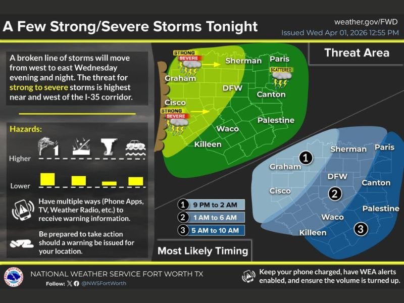
Texas Metroplex Including Dallas Fort Worth, Waco and Killeen Faces Overnight Storm Line With Strong to Severe Threat West of I-35 and 1 Inch Rain Potential
TEXAS — A developing line of thunderstorms is expected to sweep across the Dallas–Fort Worth Metroplex and surrounding areas overnight, bringing a mix of strong to severe storms, especially west of the I-35 corridor.
Forecasters indicate the system will move from west to east through the evening and overnight hours, with the most intense activity expected before gradually weakening into Thursday morning.
Strongest Storms Expected West of I-35 Corridor
The highest threat for severe weather is focused in areas west of Interstate 35, including communities such as Graham, Cisco, and nearby regions. These areas fall within the primary zone where storms could reach strong to severe levels.
As the line progresses eastward toward Dallas, Fort Worth, Waco, and Killeen, storms are expected to weaken slightly but still produce impactful weather.
Storm Timing Across the Metroplex Overnight
Timing will play a critical role in how the storms impact different areas. The western zones are expected to see activity between 9 PM and 2 AM, marking the initial wave of stronger storms.
The core Dallas–Fort Worth Metroplex is likely to experience storms between 1 AM and 6 AM, which could affect early morning commuters and overnight travel.
Further east, including areas toward Palestine and surrounding communities, activity is expected between 5 AM and 10 AM as storms continue to weaken.
Primary Hazards Include Wind, Hail and Heavy Rain
While widespread severe weather is not expected across all areas, the strongest storms could bring damaging wind gusts and hail, particularly in western zones.
In addition to severe threats, rainfall totals across the region are expected to range between 0.50 to 1.00 inch, which could lead to brief localized ponding on roads. Lightning and heavy downpours will accompany the storms, especially during peak intensity hours overnight.
Eastern Areas Likely to See Weaker Storms by Morning
As the storm system pushes eastward into Thursday morning, areas labeled as zones 2 and 3 are expected to experience weakening storms. While rain and thunder will still be present, the severe threat will diminish significantly compared to western locations. This trend suggests a gradual transition from severe to non-severe conditions as the system exits the region.
Residents Urged to Stay Alert Overnight
Officials are encouraging residents across North and Central Texas to remain weather-aware overnight, particularly in areas west of I-35 where the severe risk is highest.
Having multiple ways to receive warnings, including mobile alerts and weather radios, will be critical as storms move through during sleeping hours. As conditions evolve, residents can follow updates and share their local weather experiences with SaludaStandard-Sentinel.com.