Storms Firing Along Developing Dryline Bring Severe Weather Threat Across Western Oklahoma and Northwest Texas Monday With Bigger Risk Tuesday and Wednesday
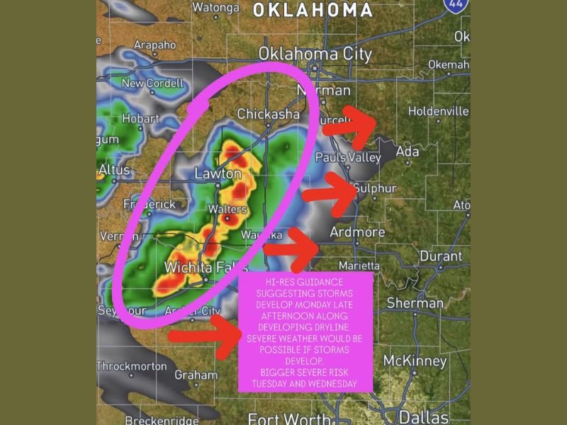
LAWTON, OK — High resolution forecast guidance was suggesting storms firing along a developing dryline across western Oklahoma and northwest Texas during Monday late afternoon and evening, with severe weather possible if storm development materialized across the Lawton, Wichita Falls, Walters, and Waynoka corridor as sufficient moisture return and cap breaking conditions appeared likely based on the latest model data.
Radar imagery showed active storm cells already developing across the Lawton and Wichita Falls area, with storm motion arrows indicating an eastward push toward Chickasha, Pauls Valley, Sulphur, and Ardmore as the dryline-initiated convection organized through the afternoon hours.
Dryline Storm Development Hinges on Moisture and Cap
Questions remained around the strength of the atmospheric cap and the depth of moisture return heading into Monday afternoon, both of which would determine whether dryline storms could fire and sustain themselves across western Oklahoma and northwest Texas. The latest high resolution guidance suggested enough moisture was present and the cap would break sufficiently to allow storm development, though the situation warranted continued monitoring as conditions evolved through the day.
If storms developed along the dryline, severe weather would be possible across the highlighted corridor, with the standard severe hazard suite of large hail, damaging winds, and tornado potential accompanying any organized supercell development along the boundary.
Bigger Severe Risk Looms Tuesday and Wednesday
While Monday’s dryline storm potential carried uncertainty, the more significant and confident severe weather threat was building for Tuesday and Wednesday across the broader region. A severe risk designation was being considered for all three days, with Tuesday and Wednesday representing the higher-confidence and potentially more impactful portion of the multi-day severe weather stretch across western Oklahoma, northwest Texas, and surrounding areas.
Residents across Lawton, Wichita Falls, Oklahoma City, Chickasha, Ardmore, and surrounding communities were advised to monitor updated forecasts closely through Monday afternoon and remain weather aware through the full Tuesday and Wednesday severe weather window.
For continuing coverage of severe weather events and critical storm analysis across the United States, visit SaludaStandard-Sentinel.com.