Record Breaking Tropical Moisture Surge Targets Florida Late Next Week With Potentially Historic Heavy Rain and Flood Threat as Deep Caribbean Moisture Crosses the State by May 29
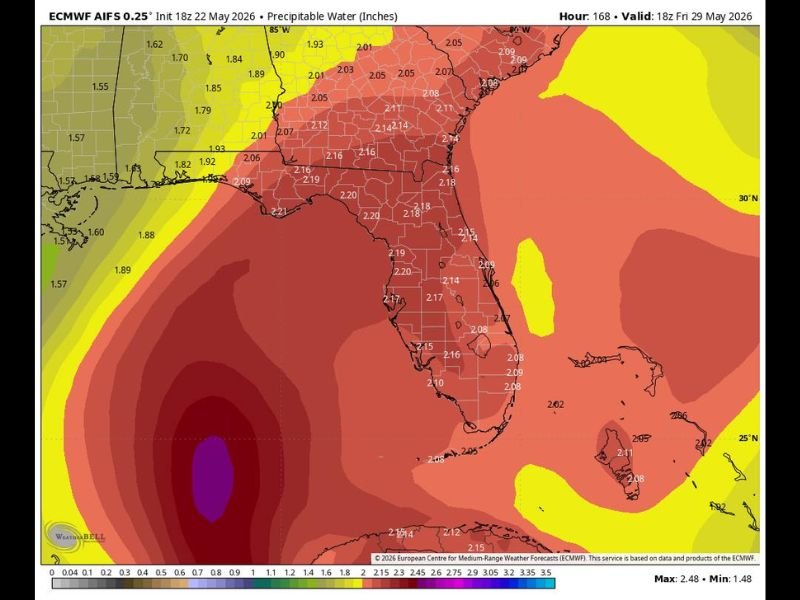
ORLANDO, FL — A strong and potentially historic heavy rain and flood threat is developing for Florida late next week into the weekend, as a surge of deep tropical moisture from the Caribbean carrying potentially record breaking atmospheric moisture values is forecast to cross the state by Friday, May 29, 2026. The ECMWF model valid at 18Z on May 29 shows precipitable water values of 2.10 to 2.21 inches blanketing the entire Florida peninsula, with the deep moisture surge representing exactly the kind of substantial rainfall event that drought stricken Florida desperately needs heading into the summer season.
ECMWF Shows Record Level Atmospheric Moisture Values Covering All of Florida by May 29
The European model precipitable water forecast valid for May 29 shows deep red shading covering the entirety of Florida, with individual precipitable water values ranging from 2.05 to 2.21 inches across the peninsula from the Panhandle southward through Miami and the Keys. These atmospheric moisture values approach and potentially exceed record levels for this time of year across Florida, providing the fuel necessary for extremely heavy rainfall rates and significant flood producing precipitation events wherever the most intense storm activity develops across the state during the late week period.
The moisture surge originates from the Caribbean and is being directed northward and across Florida by the broader atmospheric pattern, with strong wind shear over the Gulf of Mexico keeping tropical development very unlikely despite the extraordinary moisture levels involved.
Heavy Rain and Flood Threat Expected Regardless of Any Tropical Development
Forecasters emphasize that this system will be a significant rain maker for Florida regardless of whether any tropical development occurs, as the strong wind shear over the Gulf of Mexico makes tropical organization very unlikely at this time. The sheer volume of atmospheric moisture being transported across the state is sufficient on its own to produce extremely heavy rainfall, localized flooding, and potentially historic precipitation totals across portions of Florida through the late week and weekend period without requiring any named storm to develop.
Florida is currently experiencing a dire drought situation, making this incoming moisture surge a critical and welcome development for the state’s water supply, reservoir levels, and drought stressed landscapes heading into the summer months.
Florida Residents Should Monitor Updates Closely as the May 29 Timeframe Approaches
All Florida residents from the Panhandle southward through Miami are encouraged to begin monitoring updated heavy rain and flood watch information as the late May moisture surge approaches the state. The potential for record atmospheric moisture values crossing Florida means that localized flash flooding will be a serious concern in low lying areas, poor drainage zones, and flood prone communities throughout the state during the heavy rain event.
For continuing coverage of tropical moisture and flood threats across the United States, visit SaludaStandard-Sentinel.com.