Snow Chances Shift South Into Central and Southern Illinois for Sunday Night as High Pressure Limits Northern Accumulation
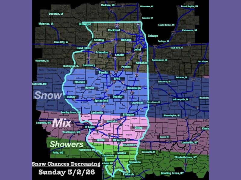
ILLINOIS — Snow chances for Sunday night have shifted farther south over the past 24 hours, with central and southern portions of the state now more likely to see light accumulation while northern Illinois trends drier.
Meteorologists say a strong area of high pressure positioned over central Illinois will keep much of the northern extent of the system suppressed. That dry air mass is expected to limit how far north steady snowfall can spread.
Central and Southern Illinois Most Likely to See Light Snow
Current projections indicate the better chance for light snow will focus from areas near Peoria, Springfield, Decatur, Champaign, and Charleston southward toward Effingham and portions of southern Illinois.
However, accumulations are expected to remain modest. Most snowfall will likely be confined to elevated surfaces such as cars, rooftops, and grassy areas.
Roadway impacts appear limited at this time, though a few slick spots cannot be ruled out, particularly late Sunday night into early Monday morning.
Northern Illinois Expected to Stay Mostly Dry
Communities farther north — including Rockford, the Quad Cities, and areas near the Wisconsin state line — are increasingly expected to remain dry due to the influence of high pressure.
Chicago and surrounding northeastern Illinois locations may see little to no accumulation as the system struggles to overcome the dry air in place.
Mixed Precipitation Possible Farther South
Far southern Illinois and areas closer to the Missouri and Kentucky borders may see a mix of precipitation types depending on temperatures. Showers could mix in at times, limiting snow totals in those southernmost counties.
Forecasters note that a more detailed snowfall map is expected to be released later tonight as confidence increases in exact placement and totals.
Limited Impacts, But Monitoring Continues
While this does not appear to be a major winter event, shifting storm tracks can still bring localized changes in totals. Residents are encouraged to monitor updated forecasts before making travel plans late Sunday.
Have snow chances increased in your area? Share your local conditions and observations at SaludaStandard-Sentinel.com.