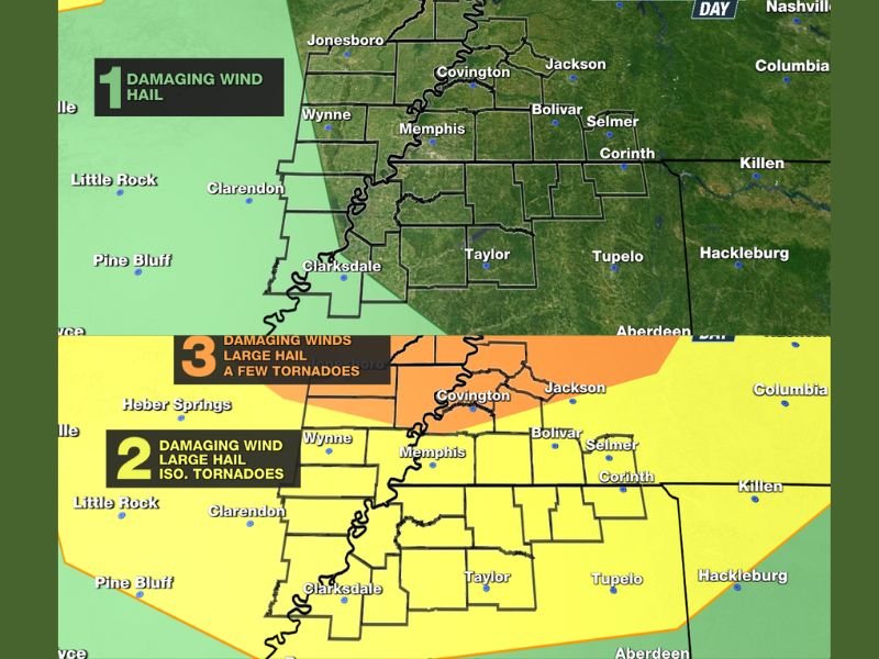
Severe Weather Day Declared for Monday Across Mid-South and Memphis Tennessee With Level 2 to 3 Risk for Tornadoes, Large Hail and Damaging Winds
MEMPHIS, TENNESSEE — A Severe Weather Day has been officially declared for Monday across the Mid-South, with numerous strong to severe thunderstorms expected during the late afternoon, evening, and overnight hours. All modes of severe weather are on the table for the region, including tornadoes, large hail, and damaging winds, as a Level 2 Slight to Level 3 Enhanced Risk covers the entire Mid-South for the primary threat window.
The storm system will arrive in multiple rounds, with the most dangerous conditions expected Monday evening and continuing into early Tuesday morning.
Sunday Stays Mostly Quiet With Isolated Concerns West of the Mississippi
Before the main event arrives Monday, Sunday brings a mostly dry and calm day across the region. Very isolated strong storms cannot be completely ruled out west of the Mississippi River across eastern Arkansas during Sunday afternoon, where a Level 1 Marginal Risk exists for spotty gusty winds and hail.
The chance of rain Sunday sits at 30 percent, with most of the area staying dry. Highs will reach the low to mid 80s with southeast winds at 5 to 10 miles per hour.
Monday Is the Day to Watch
Most of Monday remains dry and partly cloudy, but conditions will be quite windy ahead of storm development, with gusts of 30 to 40 miles per hour expected before storms even arrive. Highs will climb into the upper 80s, helping to fuel the instability that will feed the severe weather outbreak later in the day.
The chance of rain before sunset sits at 40 percent, jumping to 90 percent once the severe storm window opens late in the day. Large hail, damaging winds, and tornadoes are all possible during the late afternoon through overnight hours across the entire Mid-South.
Tuesday Brings a Second Round
The severe weather threat does not end with Monday night. Another round of strong storms is expected Tuesday afternoon and evening as a frontal boundary sits across the region. Damaging winds and large hail are the primary concerns with the Tuesday storms.
The chance of rain Tuesday sits at 70 percent, with highs in the low to mid 80s. Residents should not let their guard down after Monday night, as the Tuesday round carries its own damage potential.
Rest of the Week
Conditions improve by mid-week as rain chances decrease and temperatures stay seasonal in the low to mid 70s. A slight uptick in rain chances is possible by Friday, though no severe weather threat is anticipated at that time.
Stay weather aware Monday and download local weather apps to receive alerts the moment warnings are issued. Share your storm reports with the community at SaludaStandard-Sentinel.com.