Severe Storm Complex With 60 to 70 MPH Wind Gusts Moves Into Northwest Texas and Western Oklahoma at 9:20 PM Threatening Wichita Falls Vernon and the Lawton Corridor
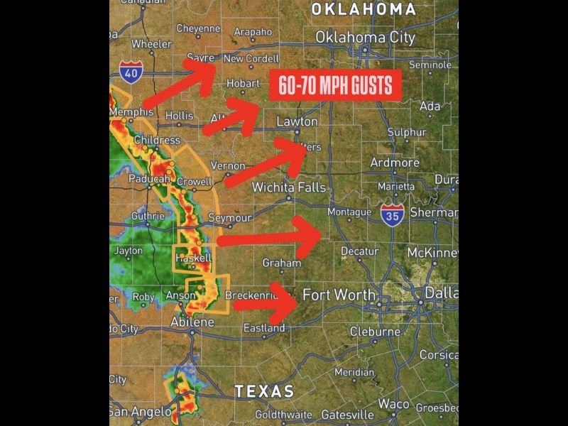
WICHITA FALLS, TX — A complex of severe storms is moving into northwest Texas and western Oklahoma at 9:20 PM, generating wind gusts of 60 to 70 miles per hour as the system pushes eastward across the region. Radar imagery shows an intense north to south oriented storm line with red and orange reflectivity returns stretching from the Childress and Paducah corridor northward toward Sayre and Hollis in western Oklahoma, with multiple directional arrows indicating the storm complex’s rapid eastward movement toward Wichita Falls, Lawton, and surrounding communities.
60 to 70 MPH Wind Gusts Threaten Communities From Northwest Texas Into Western Oklahoma
The primary hazard associated with this advancing severe storm complex is wind gusts reaching 60 to 70 miles per hour across a broad corridor from northwest Texas into western Oklahoma. Wind gusts of this magnitude are capable of downing trees, snapping power lines, causing structural damage to buildings, and creating extremely dangerous conditions for motorists across open highways throughout the affected region during the storm complex’s eastward passage through the area.
Active warning polygons outlined in orange on radar maps cover portions of the storm corridor from the Haskell and Anson areas northward, confirming that the most intense portions of the storm line are already producing warning level conditions as the complex continues its eastward movement.
Storm Line Tracks From Abilene and Childress Northward Through Vernon Toward Oklahoma
The storm complex visible on radar at 9:20 PM stretches across a lengthy north to south corridor from the Abilene and Breckenridge areas in central Texas northward through Haskell, Anson, Seymour, Vernon, Crowell, Childress, and Paducah before extending further north into western Oklahoma near Hollis and Sayre. This extensive line coverage means the 60 to 70 mph wind threat is not isolated to a single community but distributed across a wide multi-county swath as the complex moves east.
Communities along the Interstate 40 corridor in western Oklahoma including Sayre and surrounding areas face the northernmost extent of the wind threat as the storm complex pushes into that region shortly after impacting northwest Texas.
Wichita Falls Lawton and Surrounding Communities Prepare for Imminent Storm Arrival
The eastward track of this severe storm complex places Wichita Falls, Vernon, Lawton, and all communities along the storm’s projected path in line for the 60 to 70 mph wind threat within the coming hours as the line continues its rapid eastward progression. Residents across northwest Texas and western Oklahoma are urged to take shelter immediately in sturdy structures, secure any loose outdoor items, and avoid travel on open highways until the storm complex fully clears their area and conditions return to safe levels.
For continuing coverage of severe storm tracking and wind hazard warnings across the United States, visit SaludaStandard-Sentinel.com.