Scattered Showers and Storms With Gusty Winds and Heavy Rain Bursts Target North Carolina Monday With Southeastern Areas Seeing Morning Activity First
RALEIGH, NC — Scattered showers and thunderstorms are forecast to impact North Carolina throughout Monday as morning rain activity across southeastern portions of the state gives way to a broader round of afternoon and evening storms statewide, with some cells capable of producing gusty winds and heavy rainfall bursts while high temperatures climb into the 70s and 80s across most of the state.
Morning Showers Target Southeastern North Carolina First
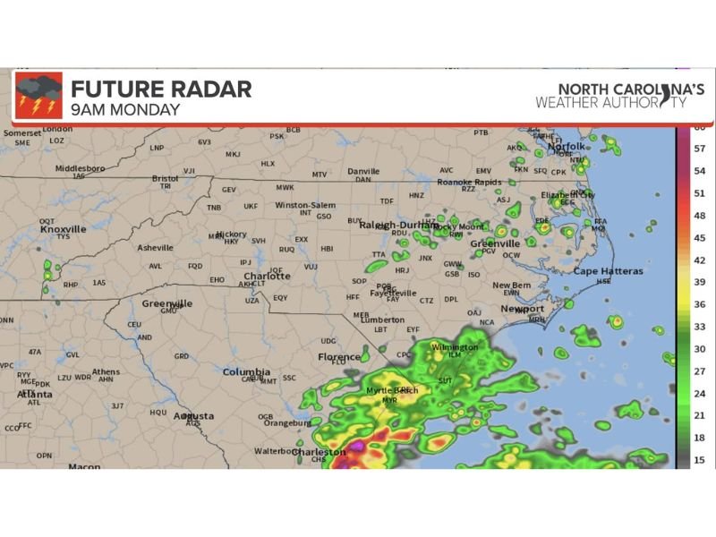
Future radar imagery valid for 9 AM Monday shows the earliest and most concentrated shower activity positioned across southeastern North Carolina, with moderate to heavy precipitation returns depicted across the Wilmington, Myrtle Beach, Lumberton, Florence, and Charleston corridor as moisture-rich air pushes onshore and interacts with morning atmospheric conditions across the coastal plain region.
Communities across southeastern North Carolina including Fayetteville, Lumberton, Wilmington, and New Bern are expected to see the most active morning precipitation, with shower activity already well established across this corridor by the 9 AM future radar timeframe while the rest of the state remains largely dry during the early morning hours.
Afternoon and Evening Storm Development Statewide
As daytime heating builds through Monday morning and into the afternoon hours, scattered showers and storms are expected to develop across a much broader geographic area of North Carolina, with the combination of surface warmth, available moisture, and afternoon instability supporting convective development from the mountains through the piedmont and coastal plain regions.
A couple of the afternoon and evening storms that develop could produce gusty wind conditions and brief but intense bursts of heavy rainfall capable of producing localized flooding concerns in areas with poor drainage or a history of water accumulation during convective rain events across the state.
Temperatures Comfortable Despite Storm Threat
Despite the active storm potential, Monday’s high temperatures across most of North Carolina are forecast to reach the 70s and low 80s, representing a comfortable and seasonable early June temperature range that will make outdoor activities pleasant during the storm-free periods between rounds of shower and storm activity throughout the day.
The combination of warm temperatures, available moisture, and afternoon heating creates a classic early summer convective pattern across North Carolina that residents should be prepared to navigate with weather awareness throughout the full Monday timeframe.
Future Radar Progression Through the Day
Sequential future radar imagery shows storm coverage remaining relatively limited and scattered during the midday hours before gradually increasing in coverage and intensity across multiple portions of the state during the mid to late afternoon and evening period as atmospheric instability peaks and storm development becomes more widespread across the North Carolina landscape.
For continuing coverage of North Carolina weather and storm developments across the United States, visit SaludaStandard-Sentinel.com.