CPC Rainfall Outlook Shows Above Normal Precipitation Likely Across Texas, the Southern Plains and Much of the Central United States From April 29 Through May 5
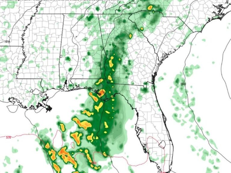
TEXAS — The latest Climate Prediction Center rainfall outlook covering April 29 through May 5 is showing strong potential for above normal precipitation across a broad stretch of the central United States, with Texas and the Southern Plains sitting at the core of the elevated rainfall signal. This comes after an already active stretch of days that has brought significant rainfall to the region, and forecasters say the active spring pattern shows no signs of slowing down heading into the final days of April and the first week of May.
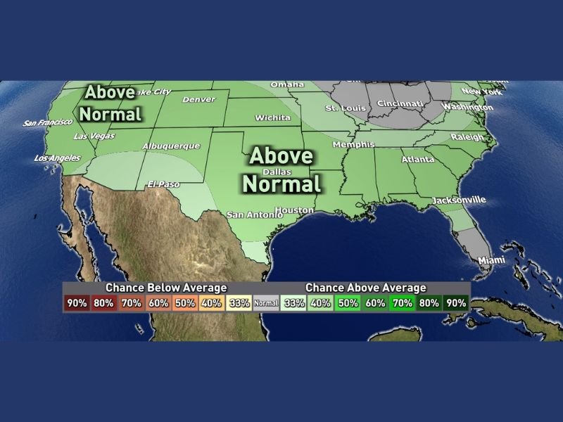
The CPC outlook map shows the above normal rainfall signal extending across a wide geographic area, covering Texas, Oklahoma, Kansas, Missouri, Memphis, Atlanta, and stretching northward toward Denver, Wichita, St. Louis, and Cincinnati.
Texas and Southern Plains at the Core of the Wet Signal
Texas sits squarely within the most prominent above normal rainfall zone on the CPC outlook map. Dallas, San Antonio, and Houston are all within the area where rainfall is expected to run above average during the April 29 through May 5 window.
The above normal signal extends northward through Oklahoma and Kansas toward Wichita, and eastward through Missouri toward St. Louis and Memphis. This broad coverage indicates that the active spring weather pattern affecting the region is expected to persist well into the first week of May.
Western and Eastern Portions of the Country Also Seeing Above Normal Signal
The above normal rainfall signal is not limited to the central United States. The western portion of the country, including San Francisco, Los Angeles, Las Vegas, Albuquerque, and Denver, is also shown within an above normal precipitation zone on the CPC outlook map.
Further east, the above normal signal extends toward Atlanta, Raleigh, Cincinnati, and Washington, suggesting a widespread wet pattern across much of the country during this timeframe. Only portions of the Gulf Coast and far southeastern states appear outside the primary above normal zone.
What Above Normal Rainfall Means for the Region
An above normal rainfall designation from the Climate Prediction Center does not guarantee heavy rain on any specific day, but rather indicates that overall precipitation totals for the period are more likely to exceed historical averages than fall below them.
For Texas and surrounding states that have already seen significant rainfall in recent days, the continuation of this wet pattern could bring additional relief to drought-affected areas while also raising concerns about flooding in low-lying and already saturated locations. Residents across the region are encouraged to monitor updated forecasts closely as the end of April approaches.
Are you seeing the active spring rainfall pattern continuing in your part of Texas or the central United States? Share your observations and stay informed with the latest weather coverage at SaludaStandard-Sentinel.com.