Scattered Rain Showers to Move Across North Carolina Saturday Afternoon and Evening Impacting Boone, Hickory, Winston-Salem, Greensboro, Durham and Raleigh
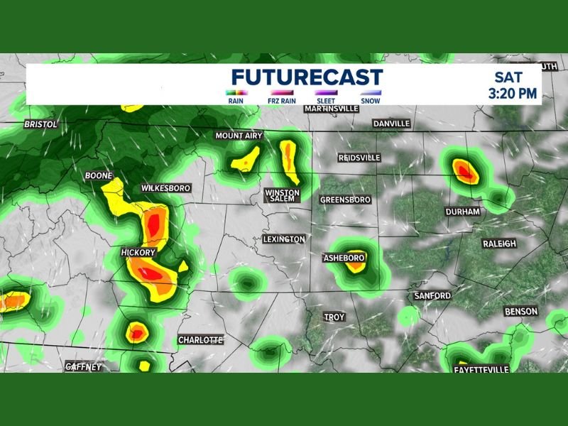
NORTH CAROLINA — Scattered rain showers are expected to move across North Carolina on Saturday, with the timing concentrated during the afternoon and evening hours. Forecasters are describing the rainfall as scattered and not soaking in nature, meaning most locations will see passing showers rather than prolonged or heavy rainfall. The WFMY News 2 Weather Impact Futurecast valid at 3:20 PM Saturday shows rain activity spread across a wide area of the state, from the western mountains through the Piedmont and into the eastern regions.
While the rain will not be a washout for most areas, residents planning outdoor activities Saturday should be prepared for periods of wet weather during the afternoon and evening.
Western Mountains and Foothills See Heaviest Showers
The most intense shower activity on Saturday afternoon is concentrated across the western mountains and foothills of North Carolina. The futurecast map shows the heaviest radar returns centered near Boone, Wilkesboro, and Hickory, where yellow and red radar signatures indicate areas of heavier rainfall within the scattered shower pattern.
Boone and the surrounding mountain communities are expected to see the most consistent rain coverage during the afternoon hours. Hickory and Wilkesboro also fall within a zone of more concentrated shower activity, with isolated pockets of heavier rain possible at times throughout the afternoon.
Piedmont Corridor Sees Scattered Activity Saturday
Across the central Piedmont corridor, shower activity becomes more scattered and less organized compared to the western mountains. Winston-Salem, Lexington, and Greensboro are all within the general rain area Saturday afternoon, with green radar returns indicating lighter and more intermittent shower coverage across this portion of the state.
Asheboro falls within a separate area of more concentrated shower activity shown on the futurecast map, while communities along the Interstate 85 corridor including Charlotte and Gaffney in neighboring South Carolina may also catch isolated showers during the afternoon and evening window.
Eastern North Carolina Sees Isolated Showers
Further east, shower coverage becomes more isolated and spotty. Durham shows a concentrated area of shower activity on the futurecast map, with green and yellow returns indicating moderate rainfall possible in that area Saturday afternoon.
Raleigh, Danville, Reidsville, Martinsville, and communities along the Virginia border may see light and isolated shower activity during the afternoon and evening, though coverage will be considerably less consistent than across the western and central portions of the state. Sanford, Troy, and Benson in the south-central region may also catch brief passing showers during the evening hours.
Are you tracking Saturday’s scattered rain showers across North Carolina? Share what conditions look like in your area and stay informed with the latest weather coverage at SaludaStandard-Sentinel.com.