Repeated Severe Weather and Multiple Days of Tornado Activity Possible Across the Central United States After May 16 as Euro Ensemble Signals Persistent Western Troughing Into Late May
CENTRAL UNITED STATES — A potentially significant and sustained severe weather pattern is developing for the latter half of May, with Euro Ensemble model data valid for May 18 showing a favorable atmospheric setup for repeated severe weather and multiple days of tornadic activity across the central United States after May 16, driven by persistent western troughing and a subtle southwest flow component that could maintain active conditions for days or even weeks.
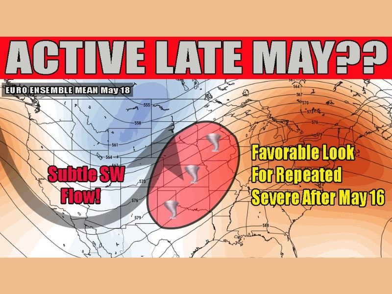
Euro Ensemble Signals Active Late May Pattern
The European Ensemble model is depicting a persistent troughing pattern across the western United States that meteorologists identify as a concerning and eyebrow-raising signal for severe weather potential during the late May period. The subtle but sustained southwest flow component associated with this trough configuration is precisely the type of atmospheric setup that, combined with late spring and early summer instability, creates the ingredients necessary for repeated daily severe weather cycles across the central plains and surrounding regions.
Euro Ensemble imagery valid for May 18 shows the favorable severe weather zone highlighted across a broad swath of the central United States, with tornado symbols indicating the tornadic threat potential embedded within the active pattern.
Multiple Days of Tornado Activity Possible After May 16
The atmospheric pattern developing after May 16 carries the potential for multiple consecutive days of tornado-producing storm activity across the central United States. The mechanism driving this sustained threat is the self-reinforcing nature of active severe weather patterns, where storms from one day leave outflow boundaries that serve as focal points for new storm development the following day, creating a repeating cycle of severe weather potential that can maintain itself for extended periods.
While the setup is not expected to produce the large-scale multi-state outbreak type events typically associated with full-scale trough ejections and surface low development, the meso-scale nature of this pattern can frequently generate significant and locally impactful tornado events across affected communities.
Localized but Significant Events Expected
The distinction between this developing pattern and a classic major outbreak setup is important for public understanding of the threat level. Rather than a single catastrophic multi-state event, the late May pattern is more likely to produce a series of localized but significant severe weather episodes affecting different portions of the central United States on successive days throughout the active period.
Residents across the central plains and surrounding regions are urged to maintain heightened weather awareness beginning after May 16 and continuing through the late May period as the active pattern establishes itself across the region.
For continuing coverage of severe weather events and critical storm analysis across the United States, visit SaludaStandard-Sentinel.com.