North Carolina Flash Floods Prompt Emergency Alerts, Road Closures
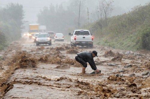
NORTH CAROLINA — Torrential rainfall has triggered life-threatening flash flooding across central and eastern North Carolina, with meteorologists warning of continued risk through midweek as storms persist across the state.
The National Weather Service (NWS) issued widespread flash flood warnings on Wednesday, citing a rare combination of persistent moisture, slow-moving storms, and already-saturated ground. Flooding was reported in urban areas, highways, underpasses, and near major creeks including Crabtree Creek, Swift Creek, Beaver Creek, and Walnut Creek.
Floodwaters Rise in Central North Carolina
According to NWS Raleigh, rainfall totals reached up to 7 inches in northeastern Chatham County and northwestern Wake County, with Franklin, Johnston, and Nash counties receiving around 5 inches. These totals overwhelmed drainage systems, making multiple roads impassable and dangerous for travel.
As flash flooding unfolded across the Research Triangle area, including Raleigh, Durham, Cary, and Apex, the flood threat was labeled “considerable,” with rain forecast to continue into Thursday. Accumulations of 1 to 3 more inches were expected, with rainfall rates up to 1.5 inches per hour in some areas.
Threat Spreads Toward the Coastal Plain
While rainfall began to ease in the central Piedmont Wednesday evening, the NWS warned that the threat was shifting to the southern and central Coastal Plain. Parts of the region had already seen 2–3 inches of rain, with additional storms tracking inland from a coastal disturbance.
In a post shared on X (formerly Twitter), NWS Raleigh wrote:
“Heavy rain is easing in the central Piedmont, but dangerous flooding continues. The threat is now increasing for the southern/central Coastal Plain. Stay alert!”
Thunderstorms and Dangerous Travel Conditions
In addition to flash flooding, active thunderstorms brought lightning and strong wind gusts, exacerbating the risk to both residents and travelers. Weather radar footage showed intense activity continuing across eastern North Carolina and parts of northeastern South Carolina.
Travelers were strongly urged not to attempt driving through water-covered roads, as most flood-related deaths occur in vehicles, according to the National Weather Service.
What Comes Next
With soaked ground from earlier storms and more moisture incoming, the flooding threat is not over. Residents are advised to monitor updates from NWS Raleigh, local emergency agencies, and live radar tools. The disturbance moving parallel to the Atlantic coast remains under close watch by the National Hurricane Center.
Have you been impacted by recent flooding in North Carolina? Share your photos, updates, and experiences in the comments to help keep your neighbors informed — only at SaludaStandard-Sentinel.com.