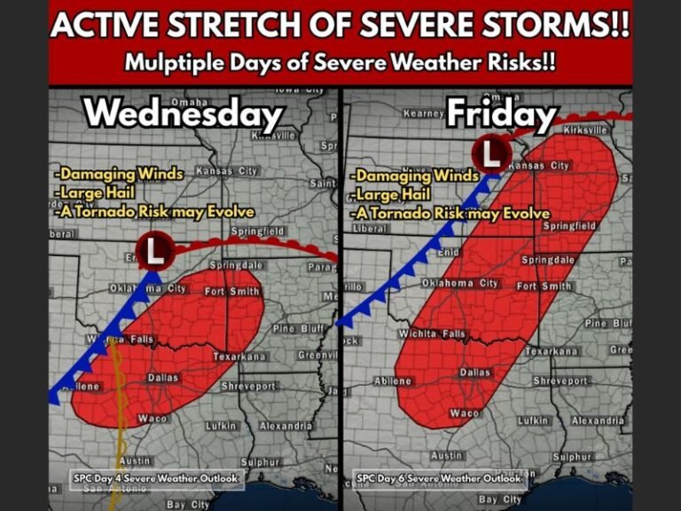
Major Cold Front Set to Sweep Across Central and Eastern U.S. Next Week
GEORGIA — The first true blast of winter air is on the way for much of the United States, as forecasters warn of a sharp temperature drop sweeping across the Midwest, Great Plains, and parts of the Southeast early next week.
According to the Global Forecast System (GFS) model map shared by meteorologists at Pivotal Weather, a massive pool of Arctic air will plunge southward by Monday, November 10, sending temperatures 10 to 25 degrees below normal across a wide swath of the country.
Meteorologists say this could mark the first major cold outbreak of the 2025–2026 winter season — arriving just as the calendar inches closer to meteorological winter, which begins December 1.
Coldest Air Targets Central and Eastern U.S.
The latest projections show the core of the coldest air centered over the central U.S., particularly impacting Missouri, Illinois, Indiana, Kentucky, Tennessee, and Arkansas, where temperatures could tumble well below average for several days.
The Midwest and Great Lakes will feel the brunt of the chill, while cold air is also expected to expand eastward into the Carolinas, Georgia, and the Mid-Atlantic by midweek.
“After an unusually mild start to November, this looks like our first legit shot of cold air,” forecasters wrote. “It’s time to dust off the jackets — winter is knocking early this year.”
Temperature Drop Could Be Steep
Forecast models show 850 mb temperature anomalies — a key upper-air indicator — plunging 10 to 20°C below normal across a large area. This will translate to surface highs in the 30s and 40s in the Midwest, and 40s to low 50s across the Southeast, including portions of South Carolina and North Carolina.
Some northern states, especially in the Upper Midwest and interior Northeast, could see their first snowflakes of the season as the Arctic air meets lingering moisture later in the week.
Meteorological Winter Nears
Meteorologists note that Meteorological Winter — defined as December through February — is less than a month away, and this pattern may serve as an early taste of what’s to come.
While it’s too early to confirm how long the cold will last, forecasters say this pattern represents a clear shift toward a winter-like regime, with more frequent cold fronts expected in the weeks ahead.
Residents across the Midwest, Ohio Valley, and Southeast should prepare for colder mornings, possible frost advisories, and an uptick in heating demand beginning next weekend.
For continuing weather coverage and safety updates across the Carolinas and the U.S., visit SaludaStandard-Sentinel.com.