Isolated Severe Thunderstorms With Hail and Damaging Winds Threaten Michigan Friday and Saturday as Active Weather Pattern Builds Through the Weekend
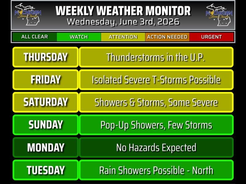
LANSING, MI — Michigan’s weekly weather monitor issued June 3, 2026 shows confidence increasing in an unsettled and potentially dangerous weather pattern developing through the upcoming weekend, with Friday and Saturday identified as the primary days of concern for isolated severe thunderstorms capable of producing hail and damaging winds while Thursday brings thunderstorm activity to the Upper Peninsula and storm chances persist into early next week.
Friday and Saturday Carry the Highest Severe Risk
The weekly weather monitor places both Friday and Saturday at the Watch level of concern, reflecting a meaningful and growing confidence among forecasters that isolated severe thunderstorm development will be possible across Michigan during both days of the weekend.
Friday’s threat centers on isolated severe thunderstorm potential with hail and wind identified as the primary hazards within any storms that reach severe limits, while Saturday carries a broader showers and storms forecast with some storms again potentially reaching severe criteria during the afternoon and evening peak heating hours across the state.
Storm Mode Still Being Determined
A key piece of uncertainty heading into the weekend involves storm mode, meaning forecasters have not yet locked in whether storms will develop as discrete supercell thunderstorms, a more organized squall line, or some combination of both modes as the weekend atmospheric setup comes into focus over the coming days.
Storm mode matters significantly because discrete supercells tend to produce larger hail and tornado potential while organized line segments are more efficient at generating widespread damaging straight line wind gusts, and the ultimate hazard profile for Friday and Saturday will depend heavily on how the storm mode question resolves as higher resolution model guidance becomes available.
Thursday Brings Upper Peninsula Storm Activity
Ahead of the main weekend event, Thursday carries a Watch level designation for thunderstorm activity across the Upper Peninsula of Michigan, where atmospheric conditions will be favorable for storm development before the more widespread severe weather pattern reaches the Lower Peninsula heading into the Friday timeframe.
Upper Peninsula residents should monitor Thursday’s storm activity closely as individual cells could produce locally heavy rainfall and lightning across the region during the afternoon and evening hours.
Sunday Through Tuesday Outlook
Storm activity is expected to continue in a more scattered and less organized form through Sunday with pop-up showers and a few storms, before Monday offers a welcome break with no hazards expected across the state.
Tuesday brings the potential for rain showers returning to northern Michigan as humidity persists across the region through the early portion of the following week. For continuing coverage of Michigan severe weather forecasts and storm threats across the United States, visit SaludaStandard-Sentinel.com.