Heavy Rain to Soak North and Central Alabama This Weekend, Birmingham and Huntsville Face Up to 3 Inches of Rainfall With 70% Rain Chances Saturday Afternoon
NORTH AND CENTRAL ALABAMA — A significant rain event is taking shape for North and Central Alabama this weekend, with models consistently signaling a soaking stretch of weather from Friday night through Sunday. Dry conditions will hold through most of Friday daytime, but the door begins opening Friday evening with a small chance of a stray shower. From there, rain chances climb quickly and do not look back until Sunday evening.
The timing of this event raises particular concern for the NASCAR Race Weekend at Talladega Superspeedway, which falls directly within the impacted zone and the heaviest part of the rainfall window.
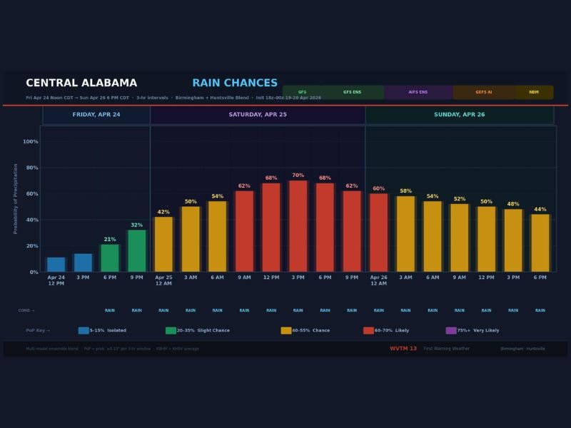
Rain Chances Peak at 70% Saturday Afternoon
Saturday afternoon is the window forecasters are watching most closely. Rain chances are expected to peak near 70% for Birmingham and climb even higher toward Huntsville and the Tennessee Valley. Overnight Friday into Saturday morning already brings a 50% chance of rain, meaning Saturday could begin wet and stay that way through much of the day.
Sunday offers little relief, with rain chances holding in the 40 to 60% range through most of the day before gradually easing off by Sunday evening. Anyone with outdoor plans across the region this weekend should have a solid backup plan in place.
Models Signal 2 to 3 Inches of Total Rainfall
Total rainfall accumulations are where this event becomes most impactful. Models are consistently signaling 2 to 3 inches of rainfall across most of North and Central Alabama by the time the system clears out Sunday evening. Huntsville and the Tennessee Valley could see the higher end of that range, with localized amounts potentially exceeding 3 inches in spots.
That volume of rainfall over a relatively short weekend window raises the possibility of localized flooding, ponding on roadways, and saturated ground conditions across the region.
Severe Weather Threat Currently Not a Primary Concern
Forecasters note there is no obvious severe weather risk associated with this system at this time, which offers some reassurance amid what is otherwise a significant rainfall event. The primary threats remain heavy rain, reduced visibility, and potential flooding rather than wind or hail damage.
However, meteorologists are continuing to monitor the pattern for any changes that could introduce a stronger storm component as the weekend approaches. Updated forecasts through Friday will provide a clearer picture of the exact timing and coverage of the heaviest rainfall bands.
Are you heading to Talladega or have outdoor plans in Alabama this weekend? Share your plans and stay updated at SaludaStandard-Sentinel.com.