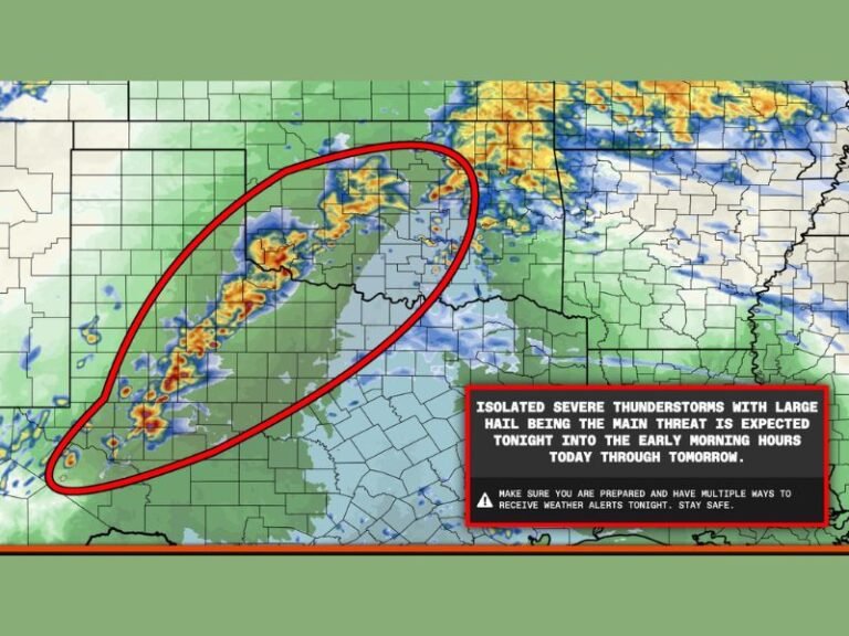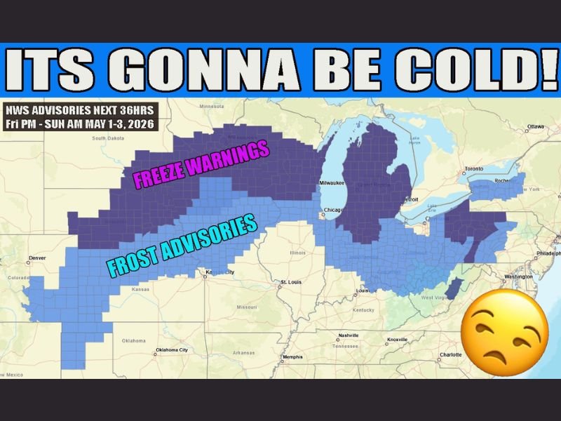
Freeze Warnings and Frost Advisories Blanket Texas Through Ohio as Late Season Cold Snap Delivers Chilly Weekend From Friday Night Through Sunday Morning May 1 to 3 2026
CENTRAL AND NORTHERN UNITED STATES — Freeze warnings and frost advisories were issued across a massive multi-state corridor stretching from Texas through Ohio as a late season cold snap delivered an unusually cold weekend from Friday evening through Sunday morning, May 1 to 3, 2026, with NWS advisories covering a broad swath of the central and northern United States through the 36-hour period.
The advisory map showed freeze warnings blanketing the northern tier of the affected region across Nebraska, Iowa, Wisconsin, Michigan, and surrounding Great Lakes states, while frost advisories extended southward through Kansas, Missouri, Illinois, Indiana, Ohio, and into portions of Kentucky and beyond.
Freeze Warnings Cover the Northern Tier
The most severe cold air impact was concentrated across the northern portions of the advisory area, where freeze warnings indicated temperatures expected to drop to or below 32 degrees Fahrenheit during the Friday night through Sunday morning window. Communities across Nebraska, Iowa, Wisconsin, Michigan, and the Great Lakes corridor fell within the freeze warning zone, placing sensitive vegetation, crops, and agricultural interests at serious risk of damaging freeze conditions during what should climatologically be a firmly established spring period.
The freeze warning coverage across the northern tier reflected the extraordinary depth and southward penetration of the cold air mass driving the late season cold snap across the central United States.
Frost Advisories Extend South Through Kansas, Missouri, and Ohio
South of the freeze warning zone, frost advisories covered a broad area stretching from Kansas and Missouri eastward through Illinois, Indiana, Ohio, and into portions of West Virginia and Kentucky. Frost advisory conditions indicated temperatures expected to drop into the middle to upper 30s, sufficient for surface frost formation across low-lying areas, open fields, and agricultural zones throughout the advisory corridor.
The combination of freeze warnings to the north and frost advisories across the central and southern portions of the affected region created a wall of cold air advisories stretching from Texas through Ohio that captured an enormous geographic footprint across the central United States during the unseasonable May cold snap.
Late Season Timing Makes the Cold Snap Particularly Notable
The arrival of freeze warnings and frost advisories across such a wide area during the first weekend of May represented a striking and historically unusual late season cold event for communities from Texas through Ohio. With growing seasons well underway and sensitive spring vegetation fully emerged across the region, the timing of the cold snap created significant agricultural concern for growers and gardeners throughout the advisory zone.
Residents across the full freeze warning and frost advisory footprint were urged to protect sensitive plants, cover vulnerable crops, and monitor local NWS updates through the Sunday morning conclusion of the 36-hour cold weather advisory period. For continuing coverage of weather events and critical storm analysis across the United States, visit SaludaStandard-Sentinel.com.