European Model Signals Strong Lightning and Severe Weather Threat Across Texas, Arkansas, Louisiana and the Southeast as Active Storm Setup Develops Early Next Week
SOUTHERN UNITED STATES — The latest data from the European Centre for Medium-Range Weather Forecasting is signaling a significant and active storm setup developing across the southern and southeastern United States early next week, with Monday emerging as the primary day of concern. Forecasters are highlighting strong lightning potential as one of the most notable threats associated with this system, along with broader severe weather concerns that have not been seen across the region in quite some time.
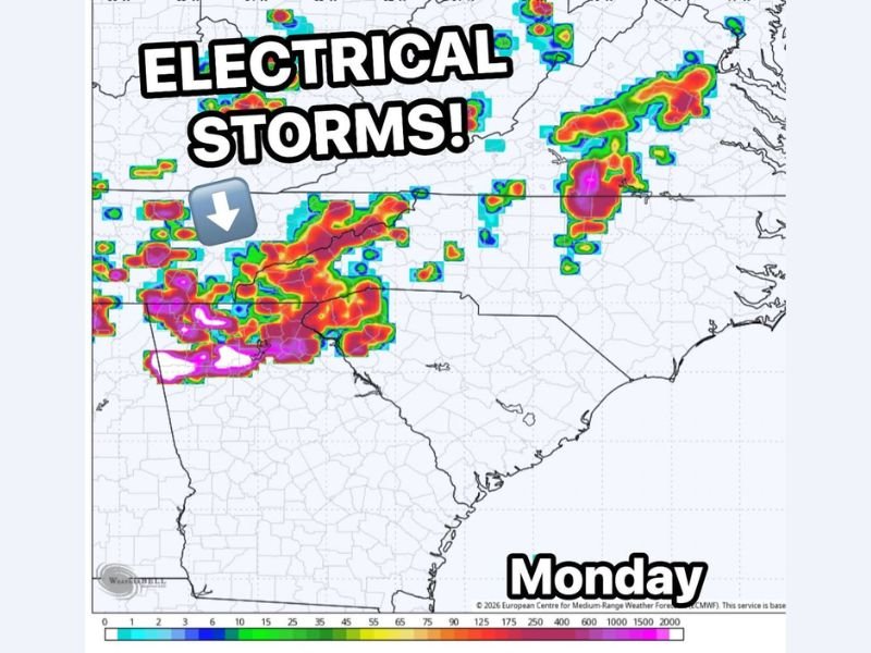
The European model lightning forecast map shows intense storm activity concentrated across a corridor spanning Texas, Arkansas, Louisiana, and extending into portions of the Southeast, with some of the highest lightning density values indicated in vivid red, purple, and magenta tones across the primary threat zone.
Where the Strongest Storm Activity Is Forecast Monday
According to the European model data, the most intense storm activity on Monday is concentrated across two primary areas. The first and most significant zone covers a broad swath from eastern Texas through Arkansas and Louisiana, where the highest lightning potential values on the map are centered. A second area of strong storm activity is indicated further northeast, extending across portions of the mid-Atlantic and Carolina coastlines, suggesting a wide geographic reach for this early week storm system.
The presence of magenta and deep purple tones on the lightning forecast map indicates extremely high lightning flash density potential, placing communities across eastern Texas, Arkansas, and Louisiana at the greatest risk for dangerous electrical storm activity Monday.
Severe Weather Concerns Accompany the Lightning Threat
Beyond the lightning hazard, forecasters are also flagging broader severe weather concerns associated with this system. The European model is depicting what meteorologists describe as an active setup, a term used when atmospheric conditions are favorably aligned for organized and potentially intense storm development.
This combination of high lightning potential and severe weather parameters makes early next week a period that residents across the affected states should monitor very closely. Forecasters have indicated they will be watching the system closely as it develops over the coming days.
What Residents Should Do to Prepare
With several days still remaining before the Monday storm threat arrives, residents across Texas, Arkansas, Louisiana, and the broader Southeast have time to prepare. Reviewing severe weather safety plans, ensuring that weather alert devices are functioning properly, and staying connected to updated local forecasts over the weekend are all recommended steps.
As this is an active and evolving setup, forecast details including storm timing, intensity, and exact threat areas are expected to be refined significantly in the coming days. Staying informed and prepared ahead of Monday will be essential for communities across the region.
Are you tracking the developing storm threat for early next week across the South and Southeast? Share your preparations and stay informed with the latest severe weather coverage at SaludaStandard-Sentinel.com.