Significant Rainfall Expected Midweek for Texas and Oklahoma as Storm Systems Shift East
DALLAS, TEXAS — After a dry stretch through the weekend, meteorologists are forecasting a return of widespread rainfall for Texas and Oklahoma by the middle of next week. The latest models show a developing storm system that will shift east from Southern California, bringing increasing rain chances starting Wednesday and continuing through Saturday.
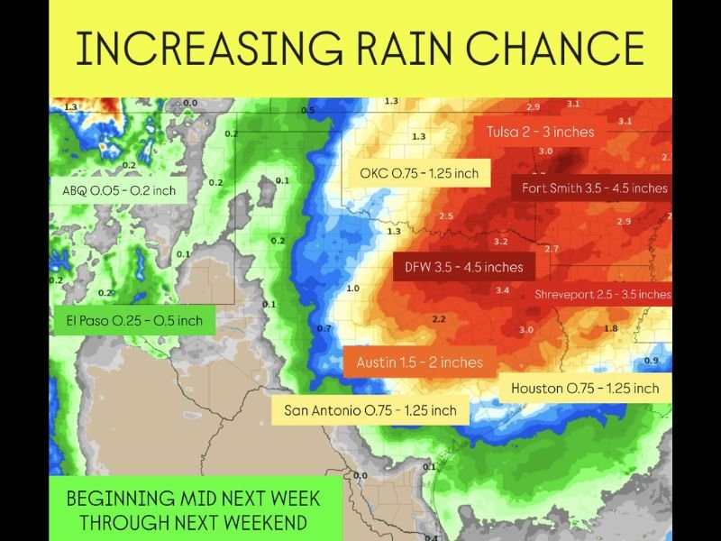
Storm System to Bring 3–4 Inches of Rain in Some Areas
According to the latest rainfall outlook, the heaviest precipitation will likely fall across north and east Texas into eastern Oklahoma and western Arkansas. Totals could range from 3.5 to 4.5 inches in areas like Dallas–Fort Worth, Fort Smith, and Shreveport, with lighter amounts west of I-35.
Forecasters expect Austin to receive 1.5 to 2 inches, while Oklahoma City, Houston, and San Antonio may see 0.75 to 1.25 inches. Smaller totals between 0.25 and 0.5 inches are forecast for El Paso and western regions.
Midweek System Marks End of Dry Period
Meteorologists say rain chances will begin to ramp up by Wednesday, peaking late Thursday into Friday, as the upper-level system moves eastward across the southern Plains. The region has been relatively dry in recent days due to a lingering ridge of high pressure that kept storms confined to the West Coast.
“This pattern finally breaks midweek,” forecasters noted, “opening the door for moisture to spread across much of Texas and Oklahoma.”
Possible Localized Flooding Concerns
With several rounds of moderate to heavy rainfall expected over multiple days, forecasters warn that localized flooding could become a concern in low-lying and urban areas, particularly where soils are already saturated.
The National Weather Service is urging residents to monitor forecasts closely through the week, as rainfall amounts may fluctuate depending on how the system tracks across the southern U.S.
Second System May Arrive Late Week
Following the initial round of rainfall, another storm system is forecast to move through Friday into Saturday, keeping showers and thunderstorms in the forecast through next weekend. The best rain chances will remain along and east of Interstate 35, including cities such as Dallas, Tulsa, and Shreveport.
Meteorologists add that while most areas will benefit from the rainfall after weeks of dry weather, cooler temperatures and unsettled conditions are expected to persist into next weekend.
Preparing for the Rain
Officials encourage residents to clear storm drains, avoid driving through flooded roads, and keep up with daily updates from local weather offices. The mid-November rain event could provide much-needed relief for drought-stricken parts of the region, but it may also create brief travel hazards due to heavy downpours.
Have you been experiencing drought or dry conditions in your area? Share your local updates and photos with us at SaludaStandard-Sentinel.com.
Author: Savannah Greene | Category: US News