First Alert Weather Day Declared for Alabama Monday as Damaging Winds Isolated Tornado and Flooding Threaten State From North to South Beginning at 3 PM
BIRMINGHAM, AL — A First Alert Weather Day has been declared for Alabama Monday as a line of severe-capable storms is expected to sweep north to south through the state throughout the afternoon and evening hours, bringing damaging straight-line winds, frequent lightning, localized flooding, and an isolated tornado threat, primarily across northern Alabama.
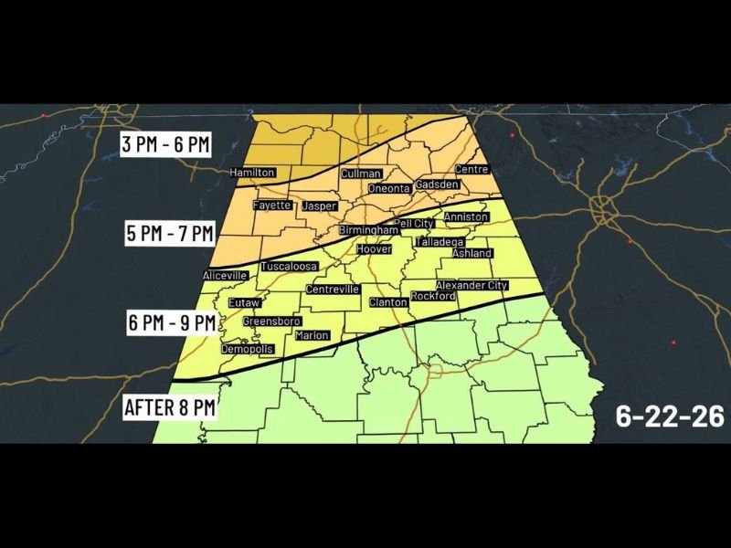
Storm Line Arrives in Northern Alabama First
Northern Alabama communities including Hamilton, Cullman, Gadsden, and Centre are expected to see storm activity arrive between 3 PM and 6 PM Monday afternoon, making them the first areas to feel the impacts of the advancing line. Temperatures across the state will heat into the 80s ahead of the storms, creating a very unstable atmosphere that will fuel storm intensity as the line pushes southward.
The combination of daytime heating and an already unstable atmosphere increases the potential for stronger storm cells to develop along the leading edge of the line as it tracks through the northern tier of the state.
Birmingham Area Sees Storms During Evening Commute
The Birmingham metro area, including Hoover, Jasper, Pell City, Tuscaloosa, and Talladega, falls within the 5 PM to 7 PM arrival window, placing the heaviest activity directly during the evening commute hours. Damaging straight-line winds remain the primary concern, though an isolated tornado cannot be ruled out across north Alabama as the line moves through.
With the ground already saturated from recent rainfall, stronger wind gusts carry an elevated risk of toppling trees and causing scattered power outages across the affected counties.
Southern Alabama Faces Impacts Into the Night
Communities farther south, including Demopolis, Greensboro, Marion, and Centreville, are expected to see the storm line push through between 6 PM and 9 PM, with areas south of that zone seeing impacts after 8 PM as the line continues accelerating southward through the evening.
Typical Summer Pattern Returns Tuesday
Rain chances are expected to decrease Tuesday, with only a few afternoon pop-up storms possible. For the remainder of the week, Alabama settles into a more typical summer pattern featuring partly sunny skies, highs in the 80s, and scattered afternoon storms, with no additional organized severe weather threat expected in the near term.
For continuing coverage of severe weather events and storm impacts across the United States, visit SaludaStandard-Sentinel.com.